1970s Maps of Pleasant Garden, North Carolina
Explore 2 historic maps of Pleasant Garden from the 1970s. These maps offer a rare glimpse into what life looked like during the 1970s — showing old roads, neighborhoods, homes, and landmarks that have changed or disappeared over time.
Whether you're researching your family's past, planning a metal detecting trip, or studying how Pleasant Garden's landscape evolved across the 1970s, these high-resolution maps are a powerful tool for exploring the history of this region.
- Focus on a specific era: All maps on this page are from the 1970s, giving you a focused view of this time period.
- See what’s changed: Compare century-old streets, trails, and buildings to today's modern landscape using overlays and satellite layers.
- Research with precision: Use these maps for genealogy, historical research, land use analysis, or educational projects.
- View, download, or print: Maps are fully viewable online in high resolution, and can be downloaded or printed for your own records.
Start exploring Pleasant Garden's history through authentic maps from the 1970s. This is your window into the past.
Pleasant Garden, NC maps
(2)- 1970 Map of Pleasant Garden, 1973 Print
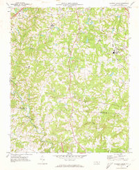 1970 Pleasant Garden1973 Print · USGSThe Piedmont countryside of Guilford and Randolph Counties is captured here in the early seventies as rural life and new growth intersected. Local historians can trace old homesteads near Burnetts Chapel, the railroad tracks through Pleasant Garden, and the winding Deep River.2 unique versions available
 - 1970 Map of Climax, 1973 Print
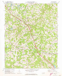 1970 Climax1973 Print · USGSThe North Carolina Piedmont south of Greensboro was undergoing significant growth in the 1970s. Researchers can trace the rural roots of Climax and Julian while locating family landmarks like the Love Ch Cem, Bethel Ch Cem, and Shiloh Ch.2 unique versions available
End of results
Showing maps 1-2 of 2
Top cities near Pleasant Garden
- Greensboro historical maps
- High Point historical maps
- Burlington historical maps
- Asheboro historical maps
- Archdale historical maps
- Gibsonville historical maps
See more
Top neighborhoods of Pleasant Garden
Frequently asked questions
- What are the different types of historical maps available for Pleasant Garden?
- What is the oldest map of Pleasant Garden?
- Where can I purchase historical maps of Pleasant Garden for my home or office?
- Where can I download high-res historical maps of Pleasant Garden?
- Are there historical topographic maps available for Pleasant Garden?
- Is there historical aerial imagery available for Pleasant Garden?
- Where are historical maps of Pleasant Garden sourced from?