1970s Maps of Gretna Green, North Carolina
Explore 2 historic maps of Gretna Green from the 1970s. These maps offer a rare glimpse into what life looked like during the 1970s — showing old roads, neighborhoods, homes, and landmarks that have changed or disappeared over time.
Whether you're researching your family's past, planning a metal detecting trip, or studying how Gretna Green's landscape evolved across the 1970s, these high-resolution maps are a powerful tool for exploring the history of this region.
- Focus on a specific era: All maps on this page are from the 1970s, giving you a focused view of this time period.
- See what’s changed: Compare century-old streets, trails, and buildings to today's modern landscape using overlays and satellite layers.
- Research with precision: Use these maps for genealogy, historical research, land use analysis, or educational projects.
- View, download, or print: Maps are fully viewable online in high resolution, and can be downloaded or printed for your own records.
Start exploring Gretna Green's history through authentic maps from the 1970s. This is your window into the past.
Gretna Green, NC maps
(2)- 1973 Map of Thelma, 1977 Print
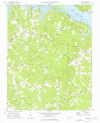 1973 Thelma1977 Print · USGSHalifax County is seen here in the 1970s as the Roanoke River reservoir system shaped the local landscape. Family historians can trace small rural communities like Summit and Gretna Green or locate churches such as Hawkins Chapel and Babbitts Chapel.2 unique versions available
 - 1976 Map of Thelma, 1979 Print
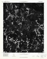 1976 Thelma1979 Print · USGSThe Roanoke River valley and the shores of Lake Gaston are captured in this mid-seventies photographic survey. Genealogists and researchers can trace rural settlements at Thelma, Summit, and Hinnant Crossroads.
End of results
Showing maps 1-2 of 2
Top cities near Gretna Green
- Roanoke Rapids historical maps
- South Rosemary historical maps
- Enfield historical maps
- Weldon historical maps
- Gaston historical maps
- Gasburg historical maps
See more
Frequently asked questions
- What are the different types of historical maps available for Gretna Green?
- What is the oldest map of Gretna Green?
- Where can I purchase historical maps of Gretna Green for my home or office?
- Where can I download high-res historical maps of Gretna Green?
- Are there historical topographic maps available for Gretna Green?
- Is there historical aerial imagery available for Gretna Green?
- Where are historical maps of Gretna Green sourced from?