1990s Maps of Cruso, North Carolina
Explore 1 historic maps of Cruso from the 1990s. These maps offer a rare glimpse into what life looked like during the 1990s — showing old roads, neighborhoods, homes, and landmarks that have changed or disappeared over time.
Whether you're researching your family's past, planning a metal detecting trip, or studying how Cruso's landscape evolved across the 1990s, these high-resolution maps are a powerful tool for exploring the history of this region.
- Focus on a specific era: All maps on this page are from the 1990s, giving you a focused view of this time period.
- See what’s changed: Compare century-old streets, trails, and buildings to today's modern landscape using overlays and satellite layers.
- Research with precision: Use these maps for genealogy, historical research, land use analysis, or educational projects.
- View, download, or print: Maps are fully viewable online in high resolution, and can be downloaded or printed for your own records.
Start exploring Cruso's history through authentic maps from the 1990s. This is your window into the past.
Cruso, NC maps
(1)- 1997 Map of Cruso, 2001 Print
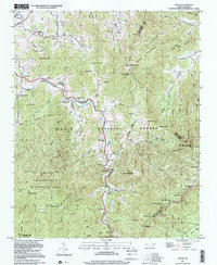 1997 Cruso2001 Print · USGSThe East Fork of the Pigeon River valley in the late 1990s remained a landscape of tight-knit mountain coves and significant wilderness peaks. Researchers can trace family history through sites like Longs Chapel, Gudger Cem, and Burnett Cove Ch located beneath the shadows of Cold Mountain.
End of results
Showing maps 1-1 of 1
Top cities near Cruso
- Asheville historical maps
- Waynesville historical maps
- Brevard historical maps
- Mills River historical maps
- Canton historical maps
- Woodfin historical maps
See more
Frequently asked questions
- What are the different types of historical maps available for Cruso?
- What is the oldest map of Cruso?
- Where can I purchase historical maps of Cruso for my home or office?
- Where can I download high-res historical maps of Cruso?
- Are there historical topographic maps available for Cruso?
- Is there historical aerial imagery available for Cruso?
- Where are historical maps of Cruso sourced from?