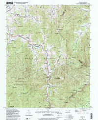
1997 Map of Cruso
USGS Topo · Published 2001About this map
The East Fork Pigeon River carves a deep valley through this corner of the Blue Ridge, anchoring the small settlement of Cruso and a string of community landmarks. Long-established churches like Longs Chapel, Mt Zion Ch, and Meadow Grove Ch follow the river’s path, marking the social centers of these mountain coves. To the west and south, the terrain rises sharply into the protected highlands of the Shining Rock Wilderness Area and Pisgah National Forest, where high summits like Cold Mountain and Mt Pisgah dominate the skyline. The presence of the Blue Ridge Parkway winding along the southern ridges, near Fryingpan Mtn Tower, illustrates the era's transition from an isolated river-and-cove economy to a landscape defined by conservation and tourism. Genealogists will find interest in the numerous family-named coves and small burial sites such as Gudger Cem that dot the lower elevations.
Find a feature on this map
77 named features on this map. Tap any name to fly to it.
Don’t see what you’re looking for? This feature index may not catch every label — zoom into the map to look around manually.
Map Details
Editions of this 1997 Cruso Map
This is the sole edition of this map. No revisions or reprints were ever made.
Other maps of this area

1894 · Asheville
USGS Topo · 1:125,000

1901 · Asheville
USGS Topo · 1:125,000

1905 · Pisgah
USGS Topo · 1:125,000

1906 · Pisgah
USGS Topo · 1:125,000

1935 · Cruso
USGS Topo · 1:24,000

1935 · Waynesville
USGS Topo · 1:24,000

1935 · Canton
USGS Topo · 1:24,000

1935 · Sam Knob
USGS Topo · 1:24,000

1935 · Clyde
USGS Topo · 1:24,000

1935 · Shining Rock
USGS Topo · 1:24,000