1940s Maps of Saunook, North Carolina
Explore 2 historic maps of Saunook from the 1940s. These maps offer a rare glimpse into what life looked like during the 1940s — showing old roads, neighborhoods, homes, and landmarks that have changed or disappeared over time.
Whether you're researching your family's past, planning a metal detecting trip, or studying how Saunook's landscape evolved across the 1940s, these high-resolution maps are a powerful tool for exploring the history of this region.
- Focus on a specific era: All maps on this page are from the 1940s, giving you a focused view of this time period.
- See what’s changed: Compare century-old streets, trails, and buildings to today's modern landscape using overlays and satellite layers.
- Research with precision: Use these maps for genealogy, historical research, land use analysis, or educational projects.
- View, download, or print: Maps are fully viewable online in high resolution, and can be downloaded or printed for your own records.
Start exploring Saunook's history through authentic maps from the 1940s. This is your window into the past.
Saunook, NC maps
(2)- 1941 Map of Hazelwood, 1957 Print
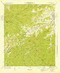
 1941 Hazelwood1957 Print · USGSThe high passes of the Plott Balsams were a vital rail and road corridor in the early 1940s. Genealogists and historians can trace the foundations of Hazelwood and Balsam, finding remote sites like the Grassy Ridge Mine and Redbank Cem.7 unique versions available
 - 1942 Map of Hazelwood
 1942 Hazelwood1942 Print · USGSThe mountain communities around WAYNESVILLE and Hazelwood are shown just before the mid-century during this era of rail travel and early industry. Trace family sites at the Allen Creek Sch or search for local landmarks like the Grassy Ridge Mine and Redbank Cem.
End of results
Showing maps 1-2 of 2
Top cities near Saunook
- Waynesville historical maps
- Cullowhee historical maps
- Canton historical maps
- Sylva historical maps
- Clyde historical maps
- Maggie Valley historical maps
See more
Frequently asked questions
- What are the different types of historical maps available for Saunook?
- What is the oldest map of Saunook?
- Where can I purchase historical maps of Saunook for my home or office?
- Where can I download high-res historical maps of Saunook?
- Are there historical topographic maps available for Saunook?
- Is there historical aerial imagery available for Saunook?
- Where are historical maps of Saunook sourced from?