1990s Maps of Hendersonville, North Carolina
Explore 2 historic maps of Hendersonville from the 1990s. These maps offer a rare glimpse into what life looked like during the 1990s — showing old roads, neighborhoods, homes, and landmarks that have changed or disappeared over time.
Whether you're researching your family's past, planning a metal detecting trip, or studying how Hendersonville's landscape evolved across the 1990s, these high-resolution maps are a powerful tool for exploring the history of this region.
- Focus on a specific era: All maps on this page are from the 1990s, giving you a focused view of this time period.
- See what’s changed: Compare century-old streets, trails, and buildings to today's modern landscape using overlays and satellite layers.
- Research with precision: Use these maps for genealogy, historical research, land use analysis, or educational projects.
- View, download, or print: Maps are fully viewable online in high resolution, and can be downloaded or printed for your own records.
Start exploring Hendersonville's history through authentic maps from the 1990s. This is your window into the past.
Hendersonville, NC maps
(2)- 1997 Map of Horse Shoe, 2001 Print
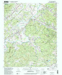 1997 Horse Shoe2001 Print · USGSHenderson County's river-bottom lands and mountain ridges are shown here in the late nineties, centered on the French Broad River. Genealogists can trace family sites like Fletcher Cem and Oak Forest Cem or visit Etowah and Horse Shoe.
 - 1997 Map of Hendersonville, 2001 Print
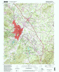 1997 Hendersonville2001 Print · USGSHendersonville and its surrounding ridges are captured in the late nineties, showcasing the growth of this mountain community along the Southern Railway. Researchers can trace local lineages through sites like Oakdale Cem, Jones Cem, and schools such as East Henderson High School.
End of results
Showing maps 1-2 of 2
Top cities near Hendersonville
- Asheville historical maps
- Fletcher historical maps
- Mills River historical maps
- Royal Pines historical maps
- Flat Rock historical maps
- Laurel Park historical maps
See more
Top neighborhoods of Hendersonville
- Plantation Walk historical maps
- Willow Bend historical maps
- Brookdale historical maps
- Carolina Village historical maps
- Glenn Brook historical maps
- Terrace Gardens historical maps
See more
Frequently asked questions
- What are the different types of historical maps available for Hendersonville?
- What is the oldest map of Hendersonville?
- Where can I purchase historical maps of Hendersonville for my home or office?
- Where can I download high-res historical maps of Hendersonville?
- Are there historical topographic maps available for Hendersonville?
- Is there historical aerial imagery available for Hendersonville?
- Where are historical maps of Hendersonville sourced from?