1970s Maps of Silver City, North Carolina
Explore 3 historic maps of Silver City from the 1970s. These maps offer a rare glimpse into what life looked like during the 1970s — showing old roads, neighborhoods, homes, and landmarks that have changed or disappeared over time.
Whether you're researching your family's past, planning a metal detecting trip, or studying how Silver City's landscape evolved across the 1970s, these high-resolution maps are a powerful tool for exploring the history of this region.
- Focus on a specific era: All maps on this page are from the 1970s, giving you a focused view of this time period.
- See what’s changed: Compare century-old streets, trails, and buildings to today's modern landscape using overlays and satellite layers.
- Research with precision: Use these maps for genealogy, historical research, land use analysis, or educational projects.
- View, download, or print: Maps are fully viewable online in high resolution, and can be downloaded or printed for your own records.
Start exploring Silver City's history through authentic maps from the 1970s. This is your window into the past.
Silver City, NC maps
(3)- 1972 Map of Raeford, 1976 Print
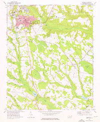 1972 Raeford1976 Print · USGSHoke County in the early seventies centers on the rail-driven growth of Raeford and its surrounding rural townships. Genealogists and local historians can trace the foundations of these communities through landmarks like Antioch Ch, Dundarrach, and Scurlock Sch.3 unique versions available
 - 1976 Map of Raeford, 1978 Print
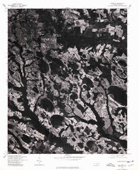 1976 Raeford1978 Print · USGSRaeford and the surrounding Hoke County countryside are captured in this mid-1970s aerial survey. Researchers can trace the development of Raeford and the rural layout around Dundarrach through high-resolution photographic imagery.
 - 1976 Map of Nicholson Creek, 1978 Print
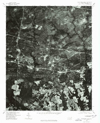 1976 Nicholson Creek1978 Print · USGSHoke County in the mid-1970s is revealed through this detailed aerial survey, showing the landscape just as it was. Genealogists and researchers can trace local landmarks like Wayside or the shoreline of Mott Lake and Nicholson Creek.
End of results
Showing maps 1-3 of 3
Top cities near Silver City
- Fayetteville historical maps
- Pinehurst historical maps
- Laurinburg historical maps
- Southern Pines historical maps
- Spring Lake historical maps
- Aberdeen historical maps
See more
Frequently asked questions
- What are the different types of historical maps available for Silver City?
- What is the oldest map of Silver City?
- Where can I purchase historical maps of Silver City for my home or office?
- Where can I download high-res historical maps of Silver City?
- Are there historical topographic maps available for Silver City?
- Is there historical aerial imagery available for Silver City?
- Where are historical maps of Silver City sourced from?