1930s Maps of Indian Place, North Carolina
Explore 1 historic maps of Indian Place from the 1930s. These maps offer a rare glimpse into what life looked like during the 1930s — showing old roads, neighborhoods, homes, and landmarks that have changed or disappeared over time.
Whether you're researching your family's past, planning a metal detecting trip, or studying how Indian Place's landscape evolved across the 1930s, these high-resolution maps are a powerful tool for exploring the history of this region.
- Focus on a specific era: All maps on this page are from the 1930s, giving you a focused view of this time period.
- See what’s changed: Compare century-old streets, trails, and buildings to today's modern landscape using overlays and satellite layers.
- Research with precision: Use these maps for genealogy, historical research, land use analysis, or educational projects.
- View, download, or print: Maps are fully viewable online in high resolution, and can be downloaded or printed for your own records.
Start exploring Indian Place's history through authentic maps from the 1930s. This is your window into the past.
Indian Place, NC maps
(1)- 1935 Map of Big Ridge
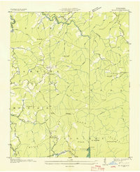 1935 Big Ridge1935 Print · USGSJackson County's high country is captured here in the mid-1930s as the TVA documented the complex river systems of the Blue Ridge. Researchers can find ancestral sites like the Big Ridge Ch, Rock Bridge Sch, and early landmarks such as Merrie Woode Camp.
End of results
Showing maps 1-1 of 1
Top cities near Indian Place
- Waynesville historical maps
- Cullowhee historical maps
- Sylva historical maps
- Webster historical maps
- Forest Hills historical maps
- Dillsboro historical maps
See more
Frequently asked questions
- What are the different types of historical maps available for Indian Place?
- What is the oldest map of Indian Place?
- Where can I purchase historical maps of Indian Place for my home or office?
- Where can I download high-res historical maps of Indian Place?
- Are there historical topographic maps available for Indian Place?
- Is there historical aerial imagery available for Indian Place?
- Where are historical maps of Indian Place sourced from?