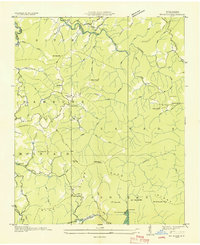
1935 Map of Big Ridge
USGS Topo · Published 1935About this map
The Tuckasegee River and its West Fork anchor this 1935 survey of Jackson County, where the Tennessee Valley Authority was actively documenting the water systems of the Blue Ridge. The landscape is a complex network of high peaks and ridges including Bell Coney Mtn, Glassy Rock Mtn, and Sheep Cliff Mtn. Local life is centered around the small settlement of Big Ridge, where the Big Ridge Ch stands near the Big Ridge itself. To the east, the Rock Bridge Sch serves the rural population near the Tuckasegee River. The map captures a moment when recreation and early infrastructure began to emerge in the high country, evidenced by Merrie Woode Camp near Fairfield Falls and a dam on the southern reaches of the river system. Township boundaries for River, Hamburg, Canada, Mountain, and Cashier's provide essential context for genealogical research.
Find a feature on this map
71 named features on this map. Tap any name to fly to it.
Don’t see what you’re looking for? This feature index may not catch every label — zoom into the map to look around manually.
Map Details
Editions of this 1935 Big Ridge Map
This is the sole edition of this map. No revisions or reprints were ever made.
Other maps of this area

1891 · Cowee
USGS Topo · 1:125,000

1897 · Cowee
USGS Topo · 1:125,000

1905 · Pisgah
USGS Topo · 1:125,000

1906 · Pisgah
USGS Topo · 1:125,000

1907 · Cowee
USGS Topo · 1:125,000

1935 · Sam Knob
USGS Topo · 1:24,000

1935 · Cashiers
USGS Topo · 1:24,000

1935 · Tuckaseigee
USGS Topo · 1:24,000

1935 · Lake Toxaway
USGS Topo · 1:24,000

1935 · Reid
USGS Topo · 1:24,000