1930s Maps of Wolftown Community, North Carolina
Explore 5 historic maps of Wolftown Community from the 1930s. These maps offer a rare glimpse into what life looked like during the 1930s — showing old roads, neighborhoods, homes, and landmarks that have changed or disappeared over time.
Whether you're researching your family's past, planning a metal detecting trip, or studying how Wolftown Community's landscape evolved across the 1930s, these high-resolution maps are a powerful tool for exploring the history of this region.
- Focus on a specific era: All maps on this page are from the 1930s, giving you a focused view of this time period.
- See what’s changed: Compare century-old streets, trails, and buildings to today's modern landscape using overlays and satellite layers.
- Research with precision: Use these maps for genealogy, historical research, land use analysis, or educational projects.
- View, download, or print: Maps are fully viewable online in high resolution, and can be downloaded or printed for your own records.
Start exploring Wolftown Community's history through authentic maps from the 1930s. This is your window into the past.
Wolftown Community, NC maps
(5)- 1933 Map of Bryson
 1933 Bryson1933 Print · USGSThe mountain valleys of Swain County are captured in the early 1930s, showing the early settlement patterns of the Great Smoky Mountains. Genealogists and historians can trace community roots through schoolhouses like Lands Creek Sch and Indian Creek Sch.
 - 1935 Map of Addie
 1935 Addie1935 Print · USGSThe Balsam Mountains and the Qualla Indian Reservation define this Jackson County landscape in the mid-thirties. Family historians can trace the Southern RR line to find rural community hubs like Beta, Scott Creek Sch, and Buff Creek Ch.
 - 1936 Map of Bunches Bald
 1936 Bunches Bald1936 Print · USGSThe high ridges and tribal lands of Swain and Jackson counties are documented here in the mid-1930s as the national park system was taking shape. Genealogists and hikers can trace the Bunches Trail, locate the Peach Tree Ch, and study the early layout of the Cherokee Indian Reservation.
 - 1936 Map of Whittier
 1936 Whittier1936 Print · USGSJackson and Swain Counties are documented here during the mid-thirties as the national park and reservation boundaries were being finalized. Researchers can locate the State Prison Camp No 512, the Southern Railway line through Wilmot, and old landmarks like Worley Chapel.
 - 1936 Map of Ravensford
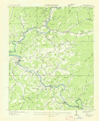
 1936 Ravensford1936 Print · USGSSwain County, North Carolina, appears here in the mid-1930s as the national park boundary was being established adjacent to tribal lands. Genealogists and local historians can locate the Big Cove Sch, Piney Grove Ch, and the riverside settlement of Ravensford.
End of results
Showing maps 1-5 of 5
Top cities near Wolftown Community
- Waynesville historical maps
- Cullowhee historical maps
- Gatlinburg historical maps
- Sylva historical maps
- Cherokee historical maps
- Bryson City historical maps
See more
Top neighborhoods of Wolftown Community
Frequently asked questions
- What are the different types of historical maps available for Wolftown Community?
- What is the oldest map of Wolftown Community?
- Where can I purchase historical maps of Wolftown Community for my home or office?
- Where can I download high-res historical maps of Wolftown Community?
- Are there historical topographic maps available for Wolftown Community?
- Is there historical aerial imagery available for Wolftown Community?
- Where are historical maps of Wolftown Community sourced from?