1960s Maps of Wolftown Community, North Carolina
Explore 6 historic maps of Wolftown Community from the 1960s. These maps offer a rare glimpse into what life looked like during the 1960s — showing old roads, neighborhoods, homes, and landmarks that have changed or disappeared over time.
Whether you're researching your family's past, planning a metal detecting trip, or studying how Wolftown Community's landscape evolved across the 1960s, these high-resolution maps are a powerful tool for exploring the history of this region.
- Focus on a specific era: All maps on this page are from the 1960s, giving you a focused view of this time period.
- See what’s changed: Compare century-old streets, trails, and buildings to today's modern landscape using overlays and satellite layers.
- Research with precision: Use these maps for genealogy, historical research, land use analysis, or educational projects.
- View, download, or print: Maps are fully viewable online in high resolution, and can be downloaded or printed for your own records.
Start exploring Wolftown Community's history through authentic maps from the 1960s. This is your window into the past.
Wolftown Community, NC maps
(6)- 1960 Map of Knoxville
 1960 Knoxville1960 Print · USGSThe Southern Appalachians come alive in the 1950s, showing the intersection of new national park tourism and deep-rooted mountain industry. Trace old rail lines like the Clinchfield RR and find high-altitude landmarks from Mt Le Conte to the Cherokee Indian Reservation.2 unique versions available
 - 1964 Map of Knoxville
 1964 Knoxville1964 Print · USGSThe Southern Appalachians and Great Smokies are captured here during the mid-sixties, showing the rugged borderlands of Tennessee and North Carolina. Researchers can trace historic mountain routes like U S 441, the expanse of Pisgah National Forest, and the growing footprints of Asheville and Knoxville.
 - 1964 Map of Smokemont, 1966 Print
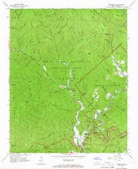 1964 Smokemont1966 Print · USGSThe Cherokee Indian Reservation and Great Smoky Mountains National Park meet in the mid-1960s at the confluence of the Oconaluftee River. Genealogists can locate several family burial sites including the Slave Cem, Sequoyah Cem, and Nations Cem.4 unique versions available
 - 1964 Map of Bunches Bald, 1967 Print
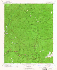 1964 Bunches Bald1967 Print · USGSSwain and Haywood counties are captured here in the mid-1960s, showing where the national park and tribal lands converge. Genealogists and hikers can trace the Masonic Monument, old peaks like Chiltoskie Mtn, and the winding Blue Ridge Parkway.3 unique versions available
 - 1967 Map of Whittier, 1970 Print
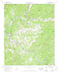 1967 Whittier1970 Print · USGSWestern North Carolina during the mid-sixties reveals the community centers of the Cherokee Indian Reservation and the mountain settlement of Whittier. Researchers can locate family landmarks like Wortley Chapel Cemetery and Rock Springs Church along the winding Tuckasegee River.5 unique versions available
 - 1967 Map of Sylva North, 1970 Print
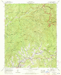 1967 Sylva North1970 Print · USGSJackson County and the Cherokee Indian Reservation are shown during a period of mid-century growth and mountain travel. Genealogists can trace family names at Keener Cem and Sutton Cem or locate community hubs like Addie and Scotts Creek School.3 unique versions available
End of results
Showing maps 1-6 of 6
Top cities near Wolftown Community
- Waynesville historical maps
- Cullowhee historical maps
- Gatlinburg historical maps
- Sylva historical maps
- Cherokee historical maps
- Bryson City historical maps
See more
Top neighborhoods of Wolftown Community
Frequently asked questions
- What are the different types of historical maps available for Wolftown Community?
- What is the oldest map of Wolftown Community?
- Where can I purchase historical maps of Wolftown Community for my home or office?
- Where can I download high-res historical maps of Wolftown Community?
- Are there historical topographic maps available for Wolftown Community?
- Is there historical aerial imagery available for Wolftown Community?
- Where are historical maps of Wolftown Community sourced from?