1970s Maps of Kenly, North Carolina
Explore 2 historic maps of Kenly from the 1970s. These maps offer a rare glimpse into what life looked like during the 1970s — showing old roads, neighborhoods, homes, and landmarks that have changed or disappeared over time.
Whether you're researching your family's past, planning a metal detecting trip, or studying how Kenly's landscape evolved across the 1970s, these high-resolution maps are a powerful tool for exploring the history of this region.
- Focus on a specific era: All maps on this page are from the 1970s, giving you a focused view of this time period.
- See what’s changed: Compare century-old streets, trails, and buildings to today's modern landscape using overlays and satellite layers.
- Research with precision: Use these maps for genealogy, historical research, land use analysis, or educational projects.
- View, download, or print: Maps are fully viewable online in high resolution, and can be downloaded or printed for your own records.
Start exploring Kenly's history through authentic maps from the 1970s. This is your window into the past.
Kenly, NC maps
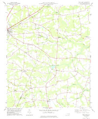
(2)- 1978 Map of Kenly West
 1978 Kenly West1978 Print · USGSThe rural landscape of Johnston County is captured here in the late seventies, showing a network of railroad towns and farming crossroads. Researchers can trace local heritage through landmarks like Lowell Mill, Oak Grove Inn, and churches such as Bethany Ch.
 - 1978 Map of Kenly East
 1978 Kenly East1978 Print · USGSCoastal plain agriculture and rail-side industry meet in this late 1970s survey of the Johnston and Wayne County borders. Genealogists can locate family burial sites, rural parishes like Daniels Chapel, and old milling sites at Sasser Millpond and Newsom Millpond.
End of results
Showing maps 1-2 of 2
Top cities near Kenly
- Wilson historical maps
- Goldsboro historical maps
- Smithfield historical maps
- Wendell historical maps
- Zebulon historical maps
- Selma historical maps
See more
Frequently asked questions
- What are the different types of historical maps available for Kenly?
- What is the oldest map of Kenly?
- Where can I purchase historical maps of Kenly for my home or office?
- Where can I download high-res historical maps of Kenly?
- Are there historical topographic maps available for Kenly?
- Is there historical aerial imagery available for Kenly?
- Where are historical maps of Kenly sourced from?