1990s Maps of Kinston, North Carolina
Explore 4 historic maps of Kinston from the 1990s. These maps offer a rare glimpse into what life looked like during the 1990s — showing old roads, neighborhoods, homes, and landmarks that have changed or disappeared over time.
Whether you're researching your family's past, planning a metal detecting trip, or studying how Kinston's landscape evolved across the 1990s, these high-resolution maps are a powerful tool for exploring the history of this region.
- Focus on a specific era: All maps on this page are from the 1990s, giving you a focused view of this time period.
- See what’s changed: Compare century-old streets, trails, and buildings to today's modern landscape using overlays and satellite layers.
- Research with precision: Use these maps for genealogy, historical research, land use analysis, or educational projects.
- View, download, or print: Maps are fully viewable online in high resolution, and can be downloaded or printed for your own records.
Start exploring Kinston's history through authentic maps from the 1990s. This is your window into the past.
Kinston, NC maps
(4)- 1998 Map of Falling Creek, 2001 Print
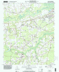
 1998 Falling Creek2001 Print · USGSWestern Kinston and the rural Lenoir-Greene county line are captured here in the late nineties, showing a landscape defined by creeks and swamps. Researchers can locate numerous local landmarks like Falling Creek Station, Banks Chapel, and the grounds of the Kennedy Mem Home.
 - 1998 Map of Rivermont, 2001 Print
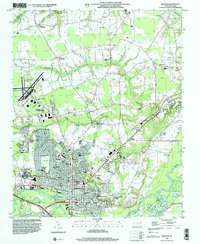
 1998 Rivermont2001 Print · USGSKinston and the surrounding coastal plain of Lenoir County come alive in this late-nineties survey of the Neuse River valley. Genealogists and local historians can locate many family landmarks and rural congregations, from Southwood and Wise Forks to Kings Chapel and Patterson Chapel.
 - 1998 Map of Kinston, 2001 Print
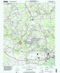
 1998 Kinston2001 Print · USGSEastern North Carolina near the turn of the millennium shows the intersection of deep-rooted rural crossroads and a growing county seat. Researchers can find long-standing community landmarks from Maplewood Cem and Grainger Stadium to the small settlement of Savannah.
 - 1998 Map of Deep Run, 2001 Print
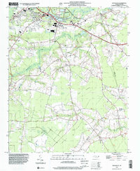
 1998 Deep Run2001 Print · USGSThe rural crossroads and river bottomlands of Lenoir County come into focus in the late nineties. Genealogists and local historians can trace family landmarks like Bucklesberry, Tulls Mill, and Hickory Grove Ch along the winding Neuse River.
End of results
Showing maps 1-4 of 4
Top cities near Kinston
- Ayden historical maps
- Winterville historical maps
- La Grange historical maps
- Snow Hill historical maps
- Pink Hill historical maps
- Hookerton historical maps
See more
Top neighborhoods of Kinston
- Club Pines historical maps
- Clubview historical maps
- Colonial Hights historical maps
- Lenoir Pines historical maps
- Edgefield Forest historical maps
- Northview historical maps
See more
Frequently asked questions
- What are the different types of historical maps available for Kinston?
- What is the oldest map of Kinston?
- Where can I purchase historical maps of Kinston for my home or office?
- Where can I download high-res historical maps of Kinston?
- Are there historical topographic maps available for Kinston?
- Is there historical aerial imagery available for Kinston?
- Where are historical maps of Kinston sourced from?