1940s Maps of Oak Grove, North Carolina
Explore 2 historic maps of Oak Grove from the 1940s. These maps offer a rare glimpse into what life looked like during the 1940s — showing old roads, neighborhoods, homes, and landmarks that have changed or disappeared over time.
Whether you're researching your family's past, planning a metal detecting trip, or studying how Oak Grove's landscape evolved across the 1940s, these high-resolution maps are a powerful tool for exploring the history of this region.
- Focus on a specific era: All maps on this page are from the 1940s, giving you a focused view of this time period.
- See what’s changed: Compare century-old streets, trails, and buildings to today's modern landscape using overlays and satellite layers.
- Research with precision: Use these maps for genealogy, historical research, land use analysis, or educational projects.
- View, download, or print: Maps are fully viewable online in high resolution, and can be downloaded or printed for your own records.
Start exploring Oak Grove's history through authentic maps from the 1940s. This is your window into the past.
Oak Grove, NC maps
(2)- 1940 Map of Alarka, 1957 Print
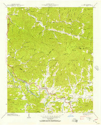 1940 Alarka1957 Print · USGSThe high ridges of Swain and Macon Counties meet here in the 1940s, showing the isolated communities of the Nantahala range. Genealogists can trace family names at Brendle Cem, the Etna post office, and old schools like Brush Creek Sch.4 unique versions available
 - 1941 Map of Alarka
 1941 Alarka1941 Print · USGSThe peaks and river bends of the Nantahala Mountains come into focus in the early 1940s, marking the border of Swain and Macon counties. Researchers can locate local landmarks like Etna, Mc Coy Bridge, and family burial grounds including Brendle Cem.
End of results
Showing maps 1-2 of 2
Top cities near Oak Grove
- Franklin historical maps
- Sylva historical maps
- Cherokee historical maps
- Bryson City historical maps
- Webster historical maps
- Dillsboro historical maps
Frequently asked questions
- What are the different types of historical maps available for Oak Grove?
- What is the oldest map of Oak Grove?
- Where can I purchase historical maps of Oak Grove for my home or office?
- Where can I download high-res historical maps of Oak Grove?
- Are there historical topographic maps available for Oak Grove?
- Is there historical aerial imagery available for Oak Grove?
- Where are historical maps of Oak Grove sourced from?