1960s Maps of Mecklenburg County, North Carolina
Explore 10 historic maps of Mecklenburg County from the 1960s. These maps offer a rare glimpse into what life looked like during the 1960s — showing old roads, neighborhoods, homes, and landmarks that have changed or disappeared over time.
Whether you're researching your family's past, planning a metal detecting trip, or studying how Mecklenburg County's landscape evolved across the 1960s, these high-resolution maps are a powerful tool for exploring the history of this region.
- Focus on a specific era: All maps on this page are from the 1960s, giving you a focused view of this time period.
- See what’s changed: Compare century-old streets, trails, and buildings to today's modern landscape using overlays and satellite layers.
- Research with precision: Use these maps for genealogy, historical research, land use analysis, or educational projects.
- View, download, or print: Maps are fully viewable online in high resolution, and can be downloaded or printed for your own records.
Start exploring Mecklenburg County's history through authentic maps from the 1960s. This is your window into the past.
Mecklenburg County, NC maps
(10)- 1960 Map of Charlotte
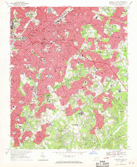
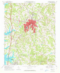
 1960 Charlotte1960 Print · USGSMid-century North Carolina and South Carolina meet in this 1960 survey of the Piedmont's industrial and textile heartland. Trace the growth of Charlotte alongside historic landmarks like Kings Mountain National Military Park and the Charlotte Naval Ammunition Depot.2 unique versions available
 - 1962 Map of Charlotte
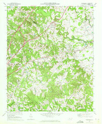
 1962 Charlotte1962 Print · USGSThe North Carolina Piedmont in the early sixties showcases a landscape transformed by massive reservoirs and industrial growth. Researchers can trace the development of Lake Norman, locate the Charlotte Naval Ammunition Depot, or find family landmarks like Wesley Chapel and Brown & Norcott Mills.
 - 1967 Map of Charlotte East, 1969 Print
 1967 Charlotte East1969 Print · USGSCharlotte is shown in a decade of rapid transformation, as its metropolitan core expands along the Southern Railway corridors. Researchers can trace the footprints of established institutions like Johnson Smith University and Evergreen Cemetery, or locate the smaller community of Rama.3 unique versions available
 - 1968 Map of Fort Mill, 1970 Print
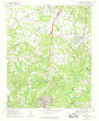 1968 Fort Mill1970 Print · USGSThe Carolina borderlands come to life in the late sixties as Fort Mill and Pineville transition from rural hubs to suburban neighborhoods. Genealogists can trace family roots at McClintock Ch, the Dinkins Cem, or near the James K Polk Birthplace.4 unique versions available
 - 1968 Map of Weddington, 1970 Print
 1968 Weddington1970 Print · USGSThe borderlands of Mecklenburg and Union counties are captured in the late sixties as suburban expansion begins to reach rural crossroads. Genealogists and local historians can trace legacy sites like Providence Ch, Weddington, and the early development of Olde Providence.4 unique versions available
 - 1968 Map of Charlotte West, 1970 Print
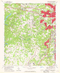 1968 Charlotte West1970 Print · USGSMecklenburg County enters a period of significant growth in the late sixties as suburban neighborhoods reach toward the Catawba River. Researchers can find traditional landmarks like Steele Creek Ch and York Mem Cemetery alongside Douglas Municipal Airport.3 unique versions available
 - 1969 Map of Mooresville, 1972 Print
 1969 Mooresville1972 Print · USGSIredell County undergoes significant change in the late sixties as the waters of Lake Norman reach into the western valleys. Genealogists and local historians can trace the foundations of Davidson College and find old landmarks like Centre Ch and Mt Mourne.3 unique versions available
 - 1969 Map of Harrisburg, 1972 Print
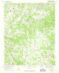
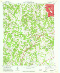
 1969 Harrisburg1972 Print · USGSThe Cabarrus and Mecklenburg county line near Harrisburg was entering a period of significant growth in the late sixties. Genealogists and local historians can trace the footprint of Roberta Mills, the early Univ of North Carolina at Charlotte, and Siloam Cem.2 unique versions available
 - 1969 Map of Kannapolis, 1972 Print
 1969 Kannapolis1972 Print · USGSKannapolis and its rural North Carolina surroundings appear here in the late sixties as the area transitioned toward suburban growth. Researchers can locate early schools and cemeteries such as Shady Brook Sch, Bethpage Ch Cem, and Wallace Crossroads.2 unique versions available
 - 1969 Map of Mountain Island Lake, 1973 Print
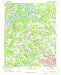 1969 Mountain Island Lake1973 Print · USGSMecklenburg County enters a period of rapid development in the late sixties as industrial infrastructure and suburban growth meet the shores of the Catawba. Genealogists can locate family landmarks such as Jennie Chapel, McGee Cemetery, and the historic Duke Power Village.2 unique versions available
End of results
Showing maps 1-10 of 10
Top cities of Mecklenburg County
- Charlotte historical maps
- Huntersville historical maps
- Matthews historical maps
- Cornelius historical maps
- Mint Hill historical maps
- Davidson historical maps
See more
Frequently asked questions
- What are the different types of historical maps available for Mecklenburg County?
- What is the oldest map of Mecklenburg County?
- Where can I purchase historical maps of Mecklenburg County for my home or office?
- Where can I download high-res historical maps of Mecklenburg County?
- Are there historical topographic maps available for Mecklenburg County?
- Is there historical aerial imagery available for Mecklenburg County?
- Where are historical maps of Mecklenburg County sourced from?