1940s Maps of Pinehurst, North Carolina
Explore 4 historic maps of Pinehurst from the 1940s. These maps offer a rare glimpse into what life looked like during the 1940s — showing old roads, neighborhoods, homes, and landmarks that have changed or disappeared over time.
Whether you're researching your family's past, planning a metal detecting trip, or studying how Pinehurst's landscape evolved across the 1940s, these high-resolution maps are a powerful tool for exploring the history of this region.
- Focus on a specific era: All maps on this page are from the 1940s, giving you a focused view of this time period.
- See what’s changed: Compare century-old streets, trails, and buildings to today's modern landscape using overlays and satellite layers.
- Research with precision: Use these maps for genealogy, historical research, land use analysis, or educational projects.
- View, download, or print: Maps are fully viewable online in high resolution, and can be downloaded or printed for your own records.
Start exploring Pinehurst's history through authentic maps from the 1940s. This is your window into the past.
Pinehurst, NC maps
(4)- 1942 Map of Troy
 1942 Troy1942 Print · USGSMid-century central North Carolina comes alive through this 1940s survey of the rail-linked towns between the Uwharrie hills and the Sandhills. Trace the historic Norfolk Southern line through Troy, Star, and Biscoe, or locate the Morrison Training School and local springs.
 - 1948 Map of Southern Pines, 1954 Print
 1948 Southern Pines1954 Print · USGSThe North Carolina Sandhills were a hub of transit and military expansion just after the war. This survey allows researchers to trace family landmarks like St Mathews Ch and Taylor Town or map the early footprints of Fort Bragg and Camp Mackall.
 - 1949 Map of West End, 1953 Print
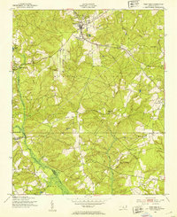 1949 West End1953 Print · USGSMoore County at the close of the 1940s reveals a landscape of growing residential pockets and established rail corridors. Genealogists and historians can trace community roots through the West End settlement, local churches like McDonalds Chapel, and the historic Jackson Springs area.3 unique versions available
 - 1949 Map of Jackson Springs, 1954 Print
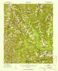 1949 Jackson Springs1954 Print · USGSThe North Carolina Sandhills were undergoing a transition in the late 1940s as military footprints expanded alongside rural farming communities. Genealogists and historians can trace the foundations of Camp Mackall and find local landmarks like the Morrison Training Sch and Jackson Springs.
End of results
Showing maps 1-4 of 4
Top cities near Pinehurst
- Southern Pines historical maps
- Aberdeen historical maps
- Seven Lakes historical maps
- Raeford historical maps
- Whispering Pines historical maps
- Carthage historical maps
See more
Top neighborhoods of Pinehurst
Frequently asked questions
- What are the different types of historical maps available for Pinehurst?
- What is the oldest map of Pinehurst?
- Where can I purchase historical maps of Pinehurst for my home or office?
- Where can I download high-res historical maps of Pinehurst?
- Are there historical topographic maps available for Pinehurst?
- Is there historical aerial imagery available for Pinehurst?
- Where are historical maps of Pinehurst sourced from?