1980s Maps of Back Swamp, North Carolina
Explore 3 historic maps of Back Swamp from the 1980s. These maps offer a rare glimpse into what life looked like during the 1980s — showing old roads, neighborhoods, homes, and landmarks that have changed or disappeared over time.
Whether you're researching your family's past, planning a metal detecting trip, or studying how Back Swamp's landscape evolved across the 1980s, these high-resolution maps are a powerful tool for exploring the history of this region.
- Focus on a specific era: All maps on this page are from the 1980s, giving you a focused view of this time period.
- See what’s changed: Compare century-old streets, trails, and buildings to today's modern landscape using overlays and satellite layers.
- Research with precision: Use these maps for genealogy, historical research, land use analysis, or educational projects.
- View, download, or print: Maps are fully viewable online in high resolution, and can be downloaded or printed for your own records.
Start exploring Back Swamp's history through authentic maps from the 1980s. This is your window into the past.
Back Swamp, NC maps
(3)- 1980 Map of Richlands
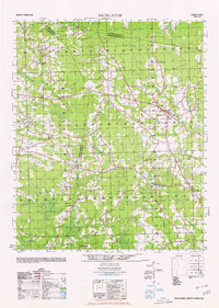 1980 Richlands1980 Print · USGSRichlands and the rural borders of Onslow, Duplin, and Jones counties are captured here at a time of deep-rooted community life. Researchers can trace family history through sites like Potters Hill Sch, Sandhill Baptist Church, and the settlement at Gregory Crossroads.
 - 1981 Map of Lyman
 1981 Lyman1981 Print · USGSCoastal plain life in Duplin County is documented here in the early eighties, showing a landscape shaped by rural industry and tradition. Genealogists can locate family landmarks like R Padnick and Horne alongside country churches like Davis Memorial Ch.
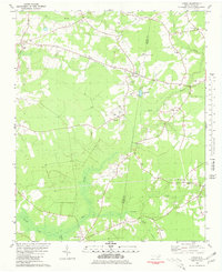
 - 1986 Map of New River
 1986 New River1986 Print · USGSCoastal Onslow County in the mid-eighties shows a landscape shaped by military expansion and the preserved wetlands of the Carolina coast. Genealogists and historians can trace the foundations of Jacksonville and small outlying communities like Richlands and Swansboro.
End of results
Showing maps 1-3 of 3
Top cities near Back Swamp
- Jacksonville historical maps
- Half Moon historical maps
- Richlands historical maps
- Beulaville historical maps
- Pink Hill historical maps
Frequently asked questions
- What are the different types of historical maps available for Back Swamp?
- What is the oldest map of Back Swamp?
- Where can I purchase historical maps of Back Swamp for my home or office?
- Where can I download high-res historical maps of Back Swamp?
- Are there historical topographic maps available for Back Swamp?
- Is there historical aerial imagery available for Back Swamp?
- Where are historical maps of Back Swamp sourced from?