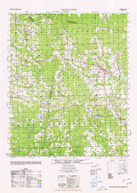
1980 Map of Richlands
USGS Topo · Published 1980About this map
Richlands and its surrounding agricultural landscape are documented here during a period of steady growth across the Onslow, Duplin, and Jones county lines. The town serves as a central hub, connected to smaller communities like Huffmantown, Jarmantown, and Petersburg by a network of rural roads. The area's social fabric is anchored by numerous spiritual and educational landmarks, including Sandhill Baptist Church, Union Chapel, and the Potters Hill Sch. The geography is defined by a dense system of waterways that drain into the New River, such as Back Swamp and Southwest Creek. A notable concentration of community centers like Quinns Store and Gregory Crossroads reflects a settlement pattern common in eastern North Carolina, where crossroads served as vital gathering points for the rural population. Significant natural features like Catherine Lake and Floyd Lake break up the wooded terrain and swampy lowlands of the Cedar Fork area.
Find a feature on this map
39 named features on this map. Tap any name to fly to it.
Don’t see what you’re looking for? This feature index may not catch every label — zoom into the map to look around manually.
Map Details
Editions of this 1980 Richlands Map
This is the sole edition of this map. No revisions or reprints were ever made.
Other maps of this area

1903 · Trent River
USGS Topo · 1:62,500

1904 · Trent River
USGS Topo · 1:62,500

1942 · Burgaw
USGS Topo · 1:62,500

1943 · Jacksonville
USGS Topo · 1:62,500

1943 · Kenansville
USGS Topo · 1:62,500

1948 · Kenansville
USGS Topo · 1:62,500

1948 · Maple Hill
USGS Topo · 1:62,500

1948 · New River
USGS Topo · 1:62,500

1948 · Richlands
USGS Topo · 1:62,500

1952 · Jacksonville South
USGS Topo · 1:24,000