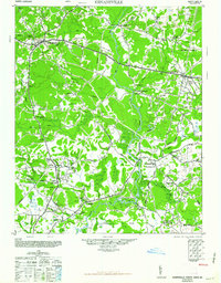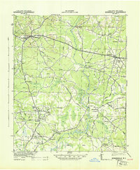
1943 Map of Kenansville
USGS Topo · Published 1943About this map
The Northeast Cape Fear River meanders through the heart of Duplin County, anchoring a landscape of rural crossroads and riverfront settlements during the early 1940s. Centered around Kenansville, the map reveals a community structured by family-named landmarks and essential gathering points such as Teacheys Store and Hancheys Store. The distribution of spiritual life is notably dense, with local congregations at Elder Creek Ch, Dobson Ch, and Jones Chapel serving as geographic anchors for the surrounding farms.
Find a feature on this map
57 named features on this map. Tap any name to fly to it.
Don’t see what you’re looking for? This feature index may not catch every label — zoom into the map to look around manually.
Map Details
Editions of this 1943 Kenansville Map
This is the sole edition of this map. No revisions or reprints were ever made.
Historical Maps of Rose Hill Through Time
8 maps found