
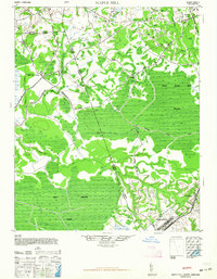
1948 Map of Maple Hill
USGS Topo · Published 1948About this map
Camp Davis stands out as a significant military installation in the southeast corner of this coastal plain landscape, which is defined by an intricate network of wetlands and creeks crossing the borders of Duplin, Pender, and Onslow counties. The area is dominated by the Holly Shelter Swamp and the unique evergreen shrub bog known as the Pocosin, illustrating the complex hydrology that historically limited large-scale development. Small rural junctions and post offices like Maple Hill, Waltons Store, and Padgett are connected by a web of named tracks such as Moores Ridge Road and Haws Run Road. The Atlantic Coast Line Railroad cuts through the southeastern portion near Folkstone, providing a vital transportation link through the difficult terrain of Juniper Swamp and Holly Shelter Creek.
Find a feature on this map
33 named features on this map. Tap any name to fly to it.
Don’t see what you’re looking for? This feature index may not catch every label — zoom into the map to look around manually.
Map Details
Editions of this 1948 Maple Hill Map
2 editions found
Other maps of this area

1942 · Spicer Bay
USGS Topo · 1:62,500

1942 · Topsail
USGS Topo · 1:62,500

1942 · Burgaw
USGS Topo · 1:62,500

1943 · Jacksonville
USGS Topo · 1:62,500

1943 · Kenansville
USGS Topo · 1:62,500

1947 · Rocky Point
USGS Topo · 1:62,500

1948 · Kenansville
USGS Topo · 1:62,500

1948 · Topsail
USGS Topo · 1:62,500

1948 · New River
USGS Topo · 1:62,500

1948 · Richlands
USGS Topo · 1:62,500