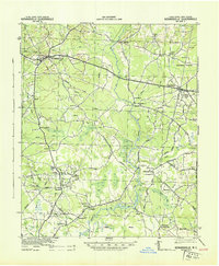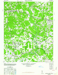
1948 Map of Kenansville
USGS Topo · Published 1948About this map
Kenansville serves as the central hub for this late 1940s landscape, where the Northeast River and its various tributaries carve through a patchwork of woodland and agriculture. The map captures a transition point in North Carolina infrastructure, highlighting the network of roads that connected rural family commerce at locations like Teacheys Store and Hancheys Store. To the north, the Logging Road near Beulaville points toward the era's timber industry, while the south is dominated by the sprawling Angola Swamp. Community life is anchored by a significant number of rural institutions, from the Elder Creek Ch to Sarecta, illustrating the density of small-scale settlement before modern highway consolidation. The proximity of the Northeast River to places like Chinquapin shows how the hydrology of Duplin County dictated the placement of these early crossroads and agricultural centers.
Find a feature on this map
51 named features on this map. Tap any name to fly to it.
Don’t see what you’re looking for? This feature index may not catch every label — zoom into the map to look around manually.
Map Details
Editions of this 1948 Kenansville Map
This is the sole edition of this map. No revisions or reprints were ever made.
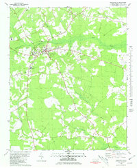
Historical Maps of Rose Hill Through Time
8 maps found