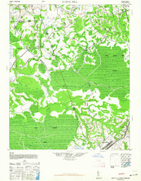
1948 Map of Maple Hill
USGS Topo · Published 1964About this map
Camp Davis anchors the southeast corner of this coastal plain landscape, marking a period of significant military presence in the region during the 1940s. The terrain is defined by an extensive network of wetlands and slow-moving water, including the massive Holly Shelter Swamp and the Great Sandy Run Pocosin. These areas suggest a history of limited development, where movement was primarily restricted to established routes like Maple Hill Road and Pierce Road.
Find a feature on this map
31 named features on this map. Tap any name to fly to it.
Don’t see what you’re looking for? This feature index may not catch every label — zoom into the map to look around manually.
Map Details
Editions of this 1948 Maple Hill Map
2 editions found
Other maps of this area

1942 · Spicer Bay
USGS Topo · 1:62,500

1942 · Topsail
USGS Topo · 1:62,500

1942 · Burgaw
USGS Topo · 1:62,500

1943 · Jacksonville
USGS Topo · 1:62,500

1943 · Kenansville
USGS Topo · 1:62,500

1947 · Rocky Point
USGS Topo · 1:62,500

1948 · Kenansville
USGS Topo · 1:62,500

1948 · Maple Hill
USGS Topo · 1:62,500

1948 · Topsail
USGS Topo · 1:62,500

1948 · New River
USGS Topo · 1:62,500