1940s Maps of Chadwick Acres, North Carolina
Explore 1 historic maps of Chadwick Acres from the 1940s. These maps offer a rare glimpse into what life looked like during the 1940s — showing old roads, neighborhoods, homes, and landmarks that have changed or disappeared over time.
Whether you're researching your family's past, planning a metal detecting trip, or studying how Chadwick Acres's landscape evolved across the 1940s, these high-resolution maps are a powerful tool for exploring the history of this region.
- Focus on a specific era: All maps on this page are from the 1940s, giving you a focused view of this time period.
- See what’s changed: Compare century-old streets, trails, and buildings to today's modern landscape using overlays and satellite layers.
- Research with precision: Use these maps for genealogy, historical research, land use analysis, or educational projects.
- View, download, or print: Maps are fully viewable online in high resolution, and can be downloaded or printed for your own records.
Start exploring Chadwick Acres's history through authentic maps from the 1940s. This is your window into the past.
Chadwick Acres, NC maps
(1)- 1948 Map of New River
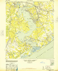 1948 New River1948 Print · USGSCoastal Onslow County underwent a massive transformation just after the war as the Marine Corps expanded its footprint along the New River. Researchers can trace early military infrastructure at the Peters Point Field Glider Base alongside civilian landmarks like Sneads Ferry and Mumfords Mill.2 unique versions available
End of results
Showing maps 1-1 of 1
Top cities near Chadwick Acres
- Jacksonville historical maps
- Piney Green historical maps
- Swansboro historical maps
- Sneads Ferry historical maps
- Surf City historical maps
- Holly Ridge historical maps
See more
Frequently asked questions
- What are the different types of historical maps available for Chadwick Acres?
- What is the oldest map of Chadwick Acres?
- Where can I purchase historical maps of Chadwick Acres for my home or office?
- Where can I download high-res historical maps of Chadwick Acres?
- Are there historical topographic maps available for Chadwick Acres?
- Is there historical aerial imagery available for Chadwick Acres?
- Where are historical maps of Chadwick Acres sourced from?