1980s Maps of Holly Ridge, North Carolina
Explore 5 historic maps of Holly Ridge from the 1980s. These maps offer a rare glimpse into what life looked like during the 1980s — showing old roads, neighborhoods, homes, and landmarks that have changed or disappeared over time.
Whether you're researching your family's past, planning a metal detecting trip, or studying how Holly Ridge's landscape evolved across the 1980s, these high-resolution maps are a powerful tool for exploring the history of this region.
- Focus on a specific era: All maps on this page are from the 1980s, giving you a focused view of this time period.
- See what’s changed: Compare century-old streets, trails, and buildings to today's modern landscape using overlays and satellite layers.
- Research with precision: Use these maps for genealogy, historical research, land use analysis, or educational projects.
- View, download, or print: Maps are fully viewable online in high resolution, and can be downloaded or printed for your own records.
Start exploring Holly Ridge's history through authentic maps from the 1980s. This is your window into the past.
Holly Ridge, NC maps
(5)- 1980 Map of Holly Ridge, 1985 Print
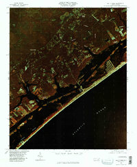 1980 Holly Ridge1985 Print · USGSThe Onslow County coast in the early eighties shows the rhythmic patterns of barrier island life and inland timbering. Genealogists and historians can locate old coastal sites like Morris Landing and Watts Landing along Topsail Sound.
 - 1980 Map of Spicer Bay, 1985 Print
 1980 Spicer Bay1985 Print · USGSThe North Carolina coast in the early eighties appears in sharp infrared detail, showing the tidal marshlands of Onslow County. Researchers can trace the shoreline of Stump Sound and locate landings like Thomas Landing and the reaches of Spicer Bay.2 unique versions available
 - 1981 Map of Folkstone
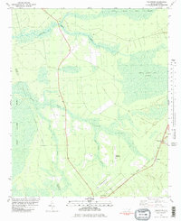 1981 Folkstone1981 Print · USGSCoastal Onslow County is shown here in the early eighties as a landscape shaped by vast wetlands and the railroad. Genealogists and local historians can trace the Seaboard Coast Line through Folkstone or locate an Abandoned Landing Strip near Holly Ridge.2 unique versions available
 - 1984 Map of Wilmington, 1985 Print
 1984 Wilmington1985 Print · USGSThe Lower Cape Fear region is shown here in the mid-1980s as the coastal corridor between Wilmington and the barrier islands experienced significant development. Researchers can trace historic river landings, the winding Intracoastal Waterway, and established communities from Castle Hayne to Topsail Beach.
 - 1986 Map of New River
 1986 New River1986 Print · USGSCoastal Onslow County in the mid-eighties shows a landscape shaped by military expansion and the preserved wetlands of the Carolina coast. Genealogists and historians can trace the foundations of Jacksonville and small outlying communities like Richlands and Swansboro.
End of results
Showing maps 1-5 of 5
Top cities near Holly Ridge
- Jacksonville historical maps
- Piney Green historical maps
- Sneads Ferry historical maps
- Surf City historical maps
- North Topsail Beach historical maps
- Topsail Beach historical maps
See more
Frequently asked questions
- What are the different types of historical maps available for Holly Ridge?
- What is the oldest map of Holly Ridge?
- Where can I purchase historical maps of Holly Ridge for my home or office?
- Where can I download high-res historical maps of Holly Ridge?
- Are there historical topographic maps available for Holly Ridge?
- Is there historical aerial imagery available for Holly Ridge?
- Where are historical maps of Holly Ridge sourced from?