1960s Maps of Orange County, North Carolina
Explore 10 historic maps of Orange County from the 1960s. These maps offer a rare glimpse into what life looked like during the 1960s — showing old roads, neighborhoods, homes, and landmarks that have changed or disappeared over time.
Whether you're researching your family's past, planning a metal detecting trip, or studying how Orange County's landscape evolved across the 1960s, these high-resolution maps are a powerful tool for exploring the history of this region.
- Focus on a specific era: All maps on this page are from the 1960s, giving you a focused view of this time period.
- See what’s changed: Compare century-old streets, trails, and buildings to today's modern landscape using overlays and satellite layers.
- Research with precision: Use these maps for genealogy, historical research, land use analysis, or educational projects.
- View, download, or print: Maps are fully viewable online in high resolution, and can be downloaded or printed for your own records.
Start exploring Orange County's history through authentic maps from the 1960s. This is your window into the past.
Orange County, NC maps
(10)- 1962 Map of Greensboro
 1962 Greensboro1962 Print · USGSThe Piedmont region along the Virginia and North Carolina border comes alive in the early 1960s, showing a landscape defined by industry and new reservoirs. Trace the path of the Virginian RR or explore the early development of Greensboro and Durham.
 - 1966 Map of Greensboro
 1966 Greensboro1966 Print · USGSThe North Carolina and Virginia Piedmont thrives during the mid-sixties, showcasing a landscape of textile hubs and expanding river reservoirs. Researchers can trace the rail corridors of the Southern Railway, find local landmarks like Elon College, or locate the extensive Camp Butner Military Reservation.
 - 1967 Map of Cedar Grove, 1969 Print
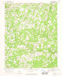
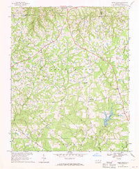 1967 Cedar Grove1969 Print · USGSNorthern Orange County's rolling hills and headwaters are captured in the late sixties as rural communities and new reservoirs shaped the land. Genealogists can trace family roots through landmarks like Harmony Cem, Mt Zion Ch, and the school at Cedar Grove.
 - 1968 Map of White Cross, 1969 Print
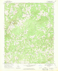 1968 White Cross1969 Print · USGSOrange County's rural crossroads and family settlements are captured here in the late sixties as the region maintained its agrarian character. Researchers can trace historic church sites like Alston Grove Ch and locate family landmarks from Thompson Mtn to Orange Grove.2 unique versions available
 - 1968 Map of Efland, 1970 Print
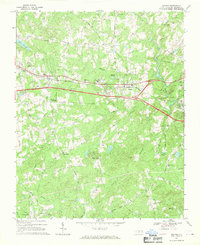 1968 Efland1970 Print · USGSOrange County's rural communities are captured here in the late sixties as the new interstate highway began to reshape the landscape. Local historians can trace the foundations of Efland and Cheeks Crossroads, alongside landmarks like Efland Millpond and the Efland-Cheeks Sch.2 unique versions available
 - 1968 Map of Hillsborough, 1970 Print
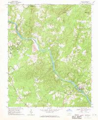
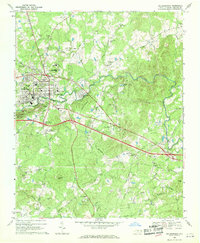 1968 Hillsborough1970 Print · USGSHillsborough and the Eno River valley are captured in the late sixties during a period of steady local growth. Researchers can locate the Governor Burke Grave, several country churches like Flat Rock Ch, and industrial sites including a Mine and Southern Railway tracks.5 unique versions available
 - 1968 Map of Caldwell, 1970 Print
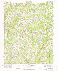
 1968 Caldwell1970 Print · USGSOrange County and the surrounding Piedmont country are captured here in the late sixties as a network of crossroads communities and small farms. Genealogists can trace family footprints across Caldwell, Schley, and numerous rural churches like Berrys Grove Ch and Olive Chapel.
 - 1968 Map of Bynum, 1970 Print
 1968 Bynum1970 Print · USGSChatham County’s rural riverfront comes to life in this late sixties survey of the Haw River valley and its surrounding hill country. Genealogists and historians can trace family roots through a dense concentration of local landmarks like Cedar Grove Ch, Gum Springs, and Hunter.
 - 1969 Map of Mebane, 1972 Print
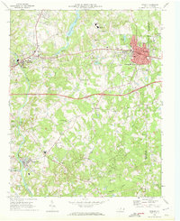 1969 Mebane1972 Print · USGSMebane and the Haw River corridor are captured here during a period of steady growth in the late sixties. Genealogists and historians can locate family landmarks like Oakwood Cem, Phillips Chapel, and the rural community of Florence Town.2 unique versions available
 - 1969 Map of Burlington NE, 1972 Print
 1969 Burlington NE1972 Print · USGSNorth Carolina's Piedmont region in the late sixties shows a landscape of rural schoolhouses and family churches at the crossroads of three counties. Researchers can trace the communities of Pleasant Grove and Just Crossroads or locate Martins Chapel and Snow Hill Ch.2 unique versions available
End of results
Showing maps 1-10 of 10
Top cities of Orange County
Frequently asked questions
- What are the different types of historical maps available for Orange County?
- What is the oldest map of Orange County?
- Where can I purchase historical maps of Orange County for my home or office?
- Where can I download high-res historical maps of Orange County?
- Are there historical topographic maps available for Orange County?
- Is there historical aerial imagery available for Orange County?
- Where are historical maps of Orange County sourced from?