1980s Maps of St. Helena, North Carolina
Explore 4 historic maps of St. Helena from the 1980s. These maps offer a rare glimpse into what life looked like during the 1980s — showing old roads, neighborhoods, homes, and landmarks that have changed or disappeared over time.
Whether you're researching your family's past, planning a metal detecting trip, or studying how St. Helena's landscape evolved across the 1980s, these high-resolution maps are a powerful tool for exploring the history of this region.
- Focus on a specific era: All maps on this page are from the 1980s, giving you a focused view of this time period.
- See what’s changed: Compare century-old streets, trails, and buildings to today's modern landscape using overlays and satellite layers.
- Research with precision: Use these maps for genealogy, historical research, land use analysis, or educational projects.
- View, download, or print: Maps are fully viewable online in high resolution, and can be downloaded or printed for your own records.
Start exploring St. Helena's history through authentic maps from the 1980s. This is your window into the past.
St. Helena, NC maps
(4)- 1980 Map of Rocky Point, 1985 Print
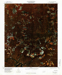 1980 Rocky Point1985 Print · USGSCoastal Pender County is shown in detail during the early eighties as agricultural fields and timberlands surrounded the river. Researchers can trace rural family sites and river landings including Rocky Point, Bells Crossroads, and Clarks Landing.
 - 1981 Map of Burgaw
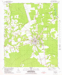 1981 Burgaw1981 Print · USGSThe Pender County seat of Burgaw and its surrounding coastal plains are shown here in the early eighties as the rail-and-river economy persisted. Genealogists can locate family landmarks such as Murray Town, James Hopewell Ch, and the settlement of Van Eden.2 unique versions available
 - 1984 Map of Wilmington, 1985 Print
 1984 Wilmington1985 Print · USGSThe Lower Cape Fear region is shown here in the mid-1980s as the coastal corridor between Wilmington and the barrier islands experienced significant development. Researchers can trace historic river landings, the winding Intracoastal Waterway, and established communities from Castle Hayne to Topsail Beach.
 - 1986 Map of New River
 1986 New River1986 Print · USGSCoastal Onslow County in the mid-eighties shows a landscape shaped by military expansion and the preserved wetlands of the Carolina coast. Genealogists and historians can trace the foundations of Jacksonville and small outlying communities like Richlands and Swansboro.
End of results
Showing maps 1-4 of 4
Top cities near St. Helena
- Burgaw historical maps
- Navassa historical maps
- Northwest historical maps
- Watha historical maps
- Hampstead historical maps
Top neighborhoods of St. Helena
Frequently asked questions
- What are the different types of historical maps available for St. Helena?
- What is the oldest map of St. Helena?
- Where can I purchase historical maps of St. Helena for my home or office?
- Where can I download high-res historical maps of St. Helena?
- Are there historical topographic maps available for St. Helena?
- Is there historical aerial imagery available for St. Helena?
- Where are historical maps of St. Helena sourced from?