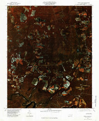
1980 Map of Rocky Point
USGS Topo · Published 1985About this map
The Northeast Cape Fear River snakes through the southern reaches of this Pender County landscape, anchoring a network of drainage that includes Turkey Creek and Morgans Creek. This 1980 color infrared orthophoto quadrangle reveals a patchwork of agricultural clearings and dense wooded tracts characteristic of the coastal plain. Small clusters of rural settlement like Rocky Point and Bells Crossroads are interspersed among larger family-named locales, including Little Kelly and Highsmith. The imagery provides a clear view of the land use patterns during this era, from the riverfront at Clarks Landing to the northern fields of Twin Oak. Unlike a traditional line-drawn map, this aerial survey records the exact texture of the vegetation and the winding paths of minor waterways like Pike Creek and Rizzo Creek as they existed in the early 1980s.
Find a feature on this map
13 named features on this map. Tap any name to fly to it.
Don’t see what you’re looking for? This feature index may not catch every label — zoom into the map to look around manually.
Map Details
Editions of this 1980 Rocky Point Map
This is the sole edition of this map. No revisions or reprints were ever made.
Other maps of this area

1942 · Burgaw
USGS Topo · 1:62,500

1947 · Rocky Point
USGS Topo · 1:62,500

1953 · Florence
USGS Topo · 1:250,000

1953 · Beaufort
USGS Topo · 1:250,000

1954 · Florence
USGS Topo · 1:250,000

1954 · Beaufort
USGS Topo · 1:250,000

1954 · Acme
USGS Topo · 1:62,500

1955 · Atkinson
USGS Topo · 1:62,500

1970 · Scotts Hill
USGS Topo · 1:24,000
1970 · Castle Hayne
USGS Topo · 1:24,000