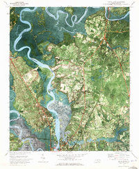
1970 Map of Castle Hayne
USGS Topo · Published 1973About this map
The Northeast Cape Fear River meanders through a landscape of tidal flats and winding creeks just north of Wilmington in this 1970 orthophotomap. This specialized series combines traditional topographic contours with aerial photography, providing a clear view of the mid-century industrial and institutional footprint on the land. Significant infrastructure includes the New Hanover County Airport and the nearby State Correctional Unit, alongside essential services like the Filtration Plant and Sewage Disposal area.
Find a feature on this map
49 named features on this map. Tap any name to fly to it.
Don’t see what you’re looking for? This feature index may not catch every label — zoom into the map to look around manually.
Map Details
Editions of this 1970 Castle Hayne Map
2 editions found
Other maps of this area

1942 · Wilmington
USGS Topo · 1:62,500

1943 · Winnabow
USGS Topo · 1:24,000

1944 · Winnabow
USGS Topo · 1:31,680

1947 · Rocky Point
USGS Topo · 1:62,500

1948 · Wilmington
USGS Topo · 1:62,500

1950 · Winnabow
USGS Topo · 1:25,000

1953 · Florence
USGS Topo · 1:250,000

1953 · Beaufort
USGS Topo · 1:250,000

1954 · Florence
USGS Topo · 1:250,000

1954 · Beaufort
USGS Topo · 1:250,000