
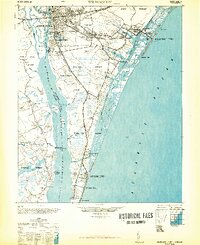
1948 Map of Wilmington
USGS Topo · Published 1948About this map
The port city of Wilmington serves as the hub of this mid-century coastal survey, showing the intricate relationship between the Cape Fear River and the Atlantic shore. The urban core is detailed with landmarks like Union Station, the Customs House, and a Masonic temple, while residential growth extends into Sunset Park and Oleander. To the east, the Inland Waterway carves through the coastal sounds, separating the mainland from barrier island developments at Wrightsville Beach and Carolina Beach.
Find a feature on this map
82 named features on this map. Tap any name to fly to it.
Don’t see what you’re looking for? This feature index may not catch every label — zoom into the map to look around manually.
Map Details
Editions of this 1948 Wilmington Map
2 editions found
Other maps of this area

1942 · Topsail
USGS Topo · 1:62,500

1942 · Wilmington
USGS Topo · 1:62,500

1943 · Funston
USGS Topo · 1:24,000

1943 · Winnabow
USGS Topo · 1:24,000

1944 · Winnabow
USGS Topo · 1:31,680

1946 · Southport
USGS Topo · 1:24,000

1946 · Snow Marsh
USGS Topo · 1:24,000

1947 · Rocky Point
USGS Topo · 1:62,500

1948 · Topsail
USGS Topo · 1:62,500

1949 · Georgetown
USGS Topo · 1:250,000