
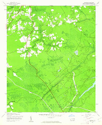
1943 Map of Funston
USGS Topo · Published 1962About this map
Brunswick Station and the rural crossroads of Funston anchor this 1943 survey of the low-lying terrain between Town Creek and Smithville in Brunswick County. The landscape is defined by an intricate network of waterways and wetlands, including the expansive Orton Pond and smaller water bodies like Pretty Pond and Clear Pond. Local connectivity during the early war years is marked by crossings such as Lewis Bridge and Allen Creek Bridge, which navigate the numerous swamps and creeks that dominate the area.
Find a feature on this map
25 named features on this map. Tap any name to fly to it.
Don’t see what you’re looking for? This feature index may not catch every label — zoom into the map to look around manually.
Map Details
Editions of this 1943 Funston Map
2 editions found
Other maps of this area

1942 · Wilmington
USGS Topo · 1:62,500

1943 · Winnabow
USGS Topo · 1:24,000

1943 · Bolivia
USGS Topo · 1:24,000

1943 · Lockwoods Folly
USGS Topo · 1:24,000

1943 · Lewis Swamp
USGS Topo · 1:24,000

1944 · Bolivia
USGS Topo · 1:31,680

1944 · Winnabow
USGS Topo · 1:31,680

1944 · Lockwoods Folly
USGS Topo · 1:31,680

1944 · Lewis Swamp
USGS Topo · 1:31,680

1946 · Southport
USGS Topo · 1:24,000