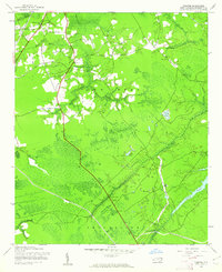
1943 Map of Funston
USGS Topo · Published 1962About this map
Low-lying coastal plains and extensive wetlands define this region of Brunswick County during the early 1940s. The landscape is dominated by complex drainage systems, where Town Creek and Smithville boundaries intersect a network of swamps and creeks. The Abandoned railroad grade cutting through the western portion of the map indicates a shift in local transportation, moving away from earlier rail dependency toward the road network connected by landmarks like Lewis Bridge and Allen Creek Bridge.
Find a feature on this map
26 named features on this map. Tap any name to fly to it.
Don’t see what you’re looking for? This feature index may not catch every label — zoom into the map to look around manually.
Map Details
Editions of this 1943 Funston Map
2 editions found
Other maps of this area

1942 · Wilmington
USGS Topo · 1:62,500

1943 · Funston
USGS Topo · 1:24,000

1943 · Winnabow
USGS Topo · 1:24,000

1943 · Bolivia
USGS Topo · 1:24,000

1943 · Lockwoods Folly
USGS Topo · 1:24,000

1943 · Lewis Swamp
USGS Topo · 1:24,000

1944 · Bolivia
USGS Topo · 1:31,680

1944 · Winnabow
USGS Topo · 1:31,680

1944 · Lockwoods Folly
USGS Topo · 1:31,680

1944 · Lewis Swamp
USGS Topo · 1:31,680