1949 Map of Georgetown
USGS Topo · Published 1953About this map
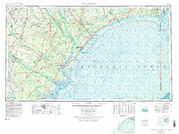
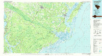
Winyah Bay serves as the central hydrographic feature of this coastal survey, where the Pee Dee River, Waccamaw River, Black River, and Sampit River converge. This 1949 data records the Lowcountry just as the Grand Strand began its postwar transformation, shown here with developing coastal points like Myrtle Beach, Garden City, and Ocean Forest linked by the Intracoastal Waterway. To the south, the Francis Marion National Forest dominates the interior, while the coastal edge is defined by the protected reaches of Cape Romain Harbor. The map captures the transition from a river-and-rail economy, evidenced by the Atlantic Coast Line Railroad and Seaboard Air Line Railroad routes through inland hubs like Conway and Kingstree, to the modern era of highway-driven coastal expansion.
Find a feature on this map
166 named features on this map. Tap any name to fly to it.
Don’t see what you’re looking for? This feature index may not catch every label — zoom into the map to look around manually.
Map Details
Editions of this 1949 Georgetown Map
This is the sole edition of this map. No revisions or reprints were ever made.
Historical Maps of Goose Creek Through Time
4 maps found