
1919 Map of Sewee Bay
USGS Topo · Published 1919About this map
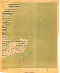
Twelvemile School, Fifteenmile School, and Eighteenmile School follow the inland progression of the Lowcountry landscape during the late First World War era. This survey, conducted in cooperation with the War Department, captures a transitional coast where industrial timbering intersected with traditional riverine settlements. A prominent Tramway cuts a diagonal path across the terrain, likely serving the logging interests that operated within the dense Iron Swamp and surrounding wooded areas.
Find a feature on this map
30 named features on this map. Tap any name to fly to it.
Don’t see what you’re looking for? This feature index may not catch every label — zoom into the map to look around manually.
Map Details
Editions of this 1919 Sewee Bay Map
This is the sole edition of this map. No revisions or reprints were ever made.
Other maps of this area

1919 · Capers Island
USGS Topo · 1:21,120

1919 · Wando
USGS Topo · 1:21,120

1919 · Cordesville
USGS Topo · 1:48,000

1919 · Fort Moultrie
USGS Topo · 1:21,120
1919 · Bulls Island
USGS Topo · 1:21,120

1943 · Capers Island
USGS Topo · 1:24,000

1943 · Fort Moultrie
USGS Topo · 1:24,000

1943 · Wando
USGS Topo · 1:24,000

1943 · Sewee Bay
USGS Topo · 1:24,000

1943 · Bulls Island
USGS Topo · 1:24,000