
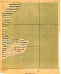
1943 Map of Bulls Island
USGS Topo · Published 1943About this map
Bulls Island sits at the heart of this coastal study, a landscape defined by its intricate network of tidal waterways and maritime history. Located in Bulls Bay along the South Carolina coast, the island is marked by the presence of an Old Fort on its northern tip and the prominent Avenue Road cutting through its center. These features suggest the island's dual role as a point of coastal defense and an established settlement or plantation site. To the north, the Intercoastal Waterway winds through the mainland marshes near Belvedere, facilitating coastal transit and trade.
Find a feature on this map
16 named features on this map. Tap any name to fly to it.
Don’t see what you’re looking for? This feature index may not catch every label — zoom into the map to look around manually.
Map Details
Editions of this 1943 Bulls Island Map
This is the sole edition of this map. No revisions or reprints were ever made.
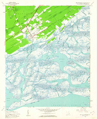
Other maps of this area

1919 · Capers Island
USGS Topo · 1:21,120
1919 · Bulls Island
USGS Topo · 1:21,120

1919 · Sewee Bay
USGS Topo · 1:21,120
1942 · Mc Clellanville
USGS Topo · 1:24,000

1943 · Capers Island
USGS Topo · 1:24,000

1943 · Sewee Bay
USGS Topo · 1:24,000

1943 · Awendaw
USGS Topo · 1:24,000
1943 · Ocean Bay
USGS Topo · 1:24,000

1948 · James Island
USGS Topo · 1:250,000

1949 · Georgetown
USGS Topo · 1:250,000