
1943 Map of Fort Moultrie
USGS Topo · Published 1943About this map
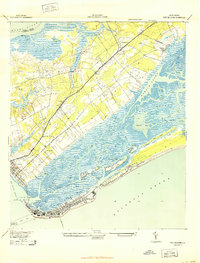
Fort Moultrie and the historic defenses of the South Carolina coast anchor this 1943 survey, revised from aerial photography just as the military presence in Charleston intensified during the war. The map documents the intricate coastal geography from the Wando River to the Atlantic Ocean, detailing the shoreline of Sullivans Island and the neighboring Isle of Palms. Settlement patterns at the time show concentrated activity in Moultrieville and Mt Pleasant, while inland areas remain dominated by rural landscapes and local landmarks like Christ Ch.
Find a feature on this map
43 named features on this map. Tap any name to fly to it.
Don’t see what you’re looking for? This feature index may not catch every label — zoom into the map to look around manually.
Map Details
Editions of this 1943 Fort Moultrie Map
2 editions found
Other maps of this area

1919 · The Jetties
USGS Topo · 1:21,120

1919 · Capers Island
USGS Topo · 1:21,120

1919 · Wando
USGS Topo · 1:21,120

1919 · Melgrove
USGS Topo · 1:21,120

1919 · Charleston
USGS Topo · 1:21,120

1919 · James Island
USGS Topo · 1:21,120

1919 · Fort Moultrie
USGS Topo · 1:21,120

1919 · Sewee Bay
USGS Topo · 1:21,120

1940 · Melgrove
USGS Topo · 1:24,000

1943 · Capers Island
USGS Topo · 1:24,000
Featured Places
- Charleston, SC
- Mount Pleasant, SC
- Isle of Palms, SC
- Waterway Arms, Mount Pleasant
- Brook Green Meadow, Mount Pleasant