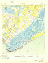
1943 Map of Fort Moultrie
USGS Topo · Published 1943About this map
Moultrieville and the historic fortifications at Fort Moultrie anchor this coastal survey, which highlights the strategic and recreational landscape of the South Carolina shore during the Second World War. The map details the intricate network of waterways including Hamlin Sound and the Intercoastal Waterway, separating the mainland from barrier features like Sullivans Island and the Isle of Palms. The interior reveals a rural community structure defined by distance-named institutions such as Fourmile Sch and Sevenmile Sch along the Georgetown Road. Local history is preserved in labels for Atlanticville P O (Fort Capron) and the coastal settlement at Porchers Bluff. The map also identifies significant military footprints beyond the forts, including a U S Rifle Range north of Mt Pleasant, reflecting the era's wartime activity near the Wando River.
Find a feature on this map
43 named features on this map. Tap any name to fly to it.
Don’t see what you’re looking for? This feature index may not catch every label — zoom into the map to look around manually.
Map Details
Editions of this 1943 Fort Moultrie Map
2 editions found

Other maps of this area

1919 · The Jetties
USGS Topo · 1:21,120

1919 · Capers Island
USGS Topo · 1:21,120

1919 · Wando
USGS Topo · 1:21,120

1919 · Melgrove
USGS Topo · 1:21,120

1919 · Charleston
USGS Topo · 1:21,120

1919 · James Island
USGS Topo · 1:21,120

1919 · Fort Moultrie
USGS Topo · 1:21,120

1919 · Sewee Bay
USGS Topo · 1:21,120

1940 · Melgrove
USGS Topo · 1:24,000

1943 · Capers Island
USGS Topo · 1:24,000
Featured Places
- Charleston, SC
- Mount Pleasant, SC
- Isle of Palms, SC
- Waterway Arms, Mount Pleasant
- Brook Green Meadow, Mount Pleasant