
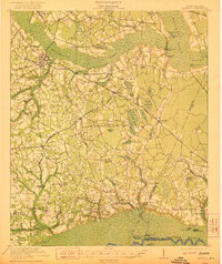
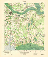
1920 Map of Mayesville
USGS Topo · Published 1920About this map
Black River and the extensive wetlands of Scape Oer Swamp dominate this rural landscape in Sumter and Clarendon counties shortly after the Great War. The settlement pattern is defined by a dense network of country churches and schools, such as St Peters Church and Witherspoon School, reflecting a deeply established agrarian community. Commercial life centers on small crossroads hubs like Wilsons Store and Brunsons Store, while industry is represented by the Woods Mill near the edge of the Douglas Swamp.
Find a feature on this map
88 named features on this map. Tap any name to fly to it.
Don’t see what you’re looking for? This feature index may not catch every label — zoom into the map to look around manually.
Map Details
Editions of this 1920 Mayesville Map
This is the sole edition of this map. No revisions or reprints were ever made.
Other maps of this area

1920 · Manning
USGS Topo · 1:48,000
1921 · Manning
USGS Topo · 1:62,500
1921 · Mayesville
USGS Topo · 1:62,500
1940 · Florence West
USGS Topo · 1:62,500

1941 · Spartanburg
USGS Topo · 1:250,000
1943 · Mayesville
USGS Topo · 1:62,500
1944 · Manning
USGS Topo · 1:62,500

1945 · Florence West
USGS Topo · 1:62,500

1946 · Kingstree
USGS Topo · 1:62,500
1946 · Lake City
USGS Topo · 1:62,500