
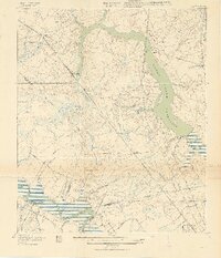
1919 Map of Ladson
USGS Topo · Published 1919About this map
Magnolia Gardens and the estate of Runnymede flank the winding Ashley River in this detailed 1919 record of the South Carolina lowcountry. The landscape is defined by the expansive Goose Creek Reservoir, which feeds into the Charleston Waterworks, highlighting the region's developing infrastructure. A complex network of railroads, including the Southern and Atlantic Coast Line, intersects at key shipping points like Ladson and Tenmile, reflecting an era where rail dominated the movement of phosphate and agricultural goods. Historical sites such as the Goose Creek Church and Jenkins Industrial School provide significant points of interest for genealogists tracing early 20th-century community hubs. The map also delineates county boundaries between Dorchester and Berkeley counties, cutting through the wetlands of Ancrum Swamp and Windsor Swamp.
Find a feature on this map
44 named features on this map. Tap any name to fly to it.
Don’t see what you’re looking for? This feature index may not catch every label — zoom into the map to look around manually.
Map Details
Editions of this 1919 Ladson Map
2 editions found
Other maps of this area

1919 · Johns Island
USGS Topo · 1:21,120

1919 · Summerville
USGS Topo · 1:48,000

1919 · Cordesville
USGS Topo · 1:48,000

1919 · Melgrove
USGS Topo · 1:21,120

1919 · Charleston
USGS Topo · 1:21,120

1920 · Ravenels
USGS Topo · 1:62,500

1920 · Summerville
USGS Topo · 1:62,500

1940 · Melgrove
USGS Topo · 1:24,000

1943 · Ladson
USGS Topo · 1:24,000

1944 · Ravenels
USGS Topo · 1:62,500