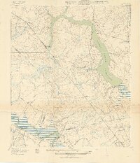
1919 Map of Ladson
USGS Topo · Published 1919About this map
Goose Creek Reservoir dominates this low-country landscape just north of Charleston, where the Charleston Waterworks manages the region's vital resources. The area is a dense network of early 20th-century transportation, crisscrossed by the Southern, Atlantic Coast Line, and Seaboard Air Line railroads. These lines connect historic riverside estates and industrial hubs, such as the Ashley Phosphate station and Ingleside. Along the banks of the Ashley River, notable sites like Magnolia Gardens and Runnymede reflect the long-standing cultural and horticultural heritage of the region.
Find a feature on this map
45 named features on this map. Tap any name to fly to it.
Don’t see what you’re looking for? This feature index may not catch every label — zoom into the map to look around manually.
Map Details
Editions of this 1919 Ladson Map
2 editions found
Other maps of this area

1919 · Ladson
USGS Topo · 1:21,120

1919 · Johns Island
USGS Topo · 1:21,120

1919 · Summerville
USGS Topo · 1:48,000

1919 · Cordesville
USGS Topo · 1:48,000

1919 · Melgrove
USGS Topo · 1:21,120

1919 · Charleston
USGS Topo · 1:21,120

1920 · Ravenels
USGS Topo · 1:62,500

1920 · Summerville
USGS Topo · 1:62,500

1940 · Melgrove
USGS Topo · 1:24,000

1943 · Ladson
USGS Topo · 1:24,000