1940s Maps of Van Eden, North Carolina
Explore 1 historic maps of Van Eden from the 1940s. These maps offer a rare glimpse into what life looked like during the 1940s — showing old roads, neighborhoods, homes, and landmarks that have changed or disappeared over time.
Whether you're researching your family's past, planning a metal detecting trip, or studying how Van Eden's landscape evolved across the 1940s, these high-resolution maps are a powerful tool for exploring the history of this region.
- Focus on a specific era: All maps on this page are from the 1940s, giving you a focused view of this time period.
- See what’s changed: Compare century-old streets, trails, and buildings to today's modern landscape using overlays and satellite layers.
- Research with precision: Use these maps for genealogy, historical research, land use analysis, or educational projects.
- View, download, or print: Maps are fully viewable online in high resolution, and can be downloaded or printed for your own records.
Start exploring Van Eden's history through authentic maps from the 1940s. This is your window into the past.
Van Eden, NC maps
(1)- 1942 Map of Burgaw
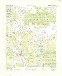 1942 Burgaw1942 Print · USGSMid-century Pender County reveals a fascinating mix of swamp wilderness and planned agricultural colonies. Genealogists and researchers can trace family lands in Penderlea Homesteads, explore the immigrant history of St. Helena, and locate features like the Prison Camp and Boney Mill Pond.2 unique versions available
End of results
Showing maps 1-1 of 1
Top cities near Van Eden
- Burgaw historical maps
- Rose Hill historical maps
- Greenevers historical maps
- Atkinson historical maps
- Teachey historical maps
- Watha historical maps
Frequently asked questions
- What are the different types of historical maps available for Van Eden?
- What is the oldest map of Van Eden?
- Where can I purchase historical maps of Van Eden for my home or office?
- Where can I download high-res historical maps of Van Eden?
- Are there historical topographic maps available for Van Eden?
- Is there historical aerial imagery available for Van Eden?
- Where are historical maps of Van Eden sourced from?