1980s Maps of Perquimans County, North Carolina
Explore 13 historic maps of Perquimans County from the 1980s. These maps offer a rare glimpse into what life looked like during the 1980s — showing old roads, neighborhoods, homes, and landmarks that have changed or disappeared over time.
Whether you're researching your family's past, planning a metal detecting trip, or studying how Perquimans County's landscape evolved across the 1980s, these high-resolution maps are a powerful tool for exploring the history of this region.
- Focus on a specific era: All maps on this page are from the 1980s, giving you a focused view of this time period.
- See what’s changed: Compare century-old streets, trails, and buildings to today's modern landscape using overlays and satellite layers.
- Research with precision: Use these maps for genealogy, historical research, land use analysis, or educational projects.
- View, download, or print: Maps are fully viewable online in high resolution, and can be downloaded or printed for your own records.
Start exploring Perquimans County's history through authentic maps from the 1980s. This is your window into the past.
Perquimans County, NC maps
(13)- 1981 Map of Edenton
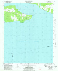
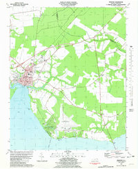 1981 Edenton1981 Print · USGSThe Albemarle Sound waterfront near the turn of the 1980s shows the historic port of Edenton alongside modern aviation and residential growth. Genealogists and researchers can trace local landmarks like Johnston Cem, St Johns Ch, and the sprawling Cape Colony development.2 unique versions available
 - 1982 Map of Nixonton
 1982 Nixonton1982 Print · USGSEastern North Carolina's tidewater landscape appears in the early 1980s as a patchwork of riverfront landings and rural crossroads. Genealogists can trace family names through sites like Wilson Cem, Godfrey Cem, and the riverfront settlement at Nixonton.
 - 1982 Map of Yeopim River
 1982 Yeopim River1982 Print · USGSCoastal North Carolina in the early eighties shows a landscape of riverfront growth and quiet rural tradition. Researchers can trace family-named sites like Philips Landing and Nixons Beach or locate old community centers such as New Haven Ch.
 - 1982 Map of Center Hill
 1982 Center Hill1982 Print · USGSThe lowlands of Perquimans and Chowan counties are captured here in the early eighties, defined by the vast Bear Swamp and the Perquimans River. Genealogists can trace family roots through several rural congregations like Happy Home Ch and numerous small country Cemeteries.
 - 1982 Map of Harvey
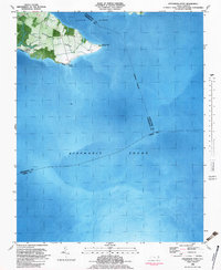
 1982 Harvey1982 Print · USGSCoastal Perquimans County in the early eighties was a landscape defined by military testing and tidal waters. You can trace the footprint of the Harvey Point Defense Testing Activity or locate family sites like Harvey Cem and Newby Landing.
 - 1982 Map of Weeksville
 1982 Weeksville1982 Print · USGSCoastal Pasquotank County is seen here in the early eighties as a landscape of tidewater creeks and established rural communities. Trace the grounds of the USCG Airbase or locate local landmarks like Newbegun Ch and Listers Corner near the Albemarle Sound.
 - 1982 Map of Pasquotank
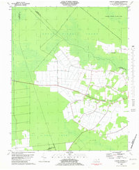
 1982 Pasquotank1982 Print · USGSIn the early 1980s, the edge of the Great Dismal Swamp met the expanding infrastructure of Elizabeth City and the Pasquotank River. Researchers can trace the layout of community landmarks like Albemarle Academy, Samuel Chapel, and the industrial corridors of the NORFOLK SOUTHERN railroad.
 - 1982 Map of Chapanoke
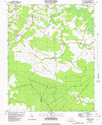
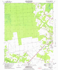
 1982 Chapanoke1982 Print · USGSPerquimans County in the early eighties was defined by the intersection of rural settlements and the southern edge of the Great Dismal Swamp. Genealogists and local historians can trace family roots at Up River Ch or locate the paths of the Norfolk Southern and an Old Railroad Grade.
 - 1982 Map of Lynchs Corner
 1982 Lynchs Corner1982 Print · USGSThe Pasquotank County wetlands in the early eighties were a complex mosaic of conservation and remote settlements. Researchers can trace the legacy of the swamp through the Old Railroad Grade and find local landmarks like Ramoth Gilead Ch and Lynchs Corner.
 - 1982 Map of Hertford
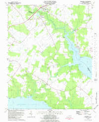
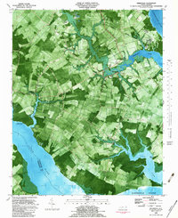
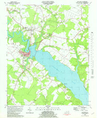 1982 Hertford1982 Print · USGSThe riverfront culture of Perquimans County is on full display in the early 1980s as Hertford and Winfall straddle the water. Trace the footprints of rural life through family-named landmarks like Smithtown and numerous local meeting houses like Oak Hill Ch and Poplar Run Ch.
 - 1982 Map of Hobbsville
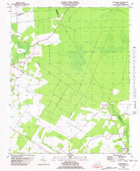
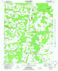 1982 Hobbsville1982 Print · USGSCoastal plain farming and the fringes of the Great Dismal Swamp define this corner of North Carolina in the early eighties. Genealogists and local historians can trace family roots through numerous landmarks like Winslow Grove Ch, Belvidere, and the Old Railroad Grade.
 - 1982 Map of Stevenson Point, 1983 Print
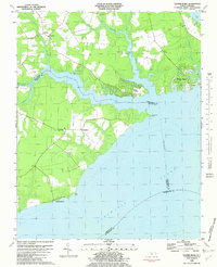
 1982 Stevenson Point1983 Print · USGSCoastal Perquimans County is documented here in the early eighties as the peninsula of Durants Neck meets the sound. Researchers can trace shoreline developments like Carolina Shores or locate landmarks such as Leighs Temple and Reed Point.
 - 1985 Map of Elizabeth City
 1985 Elizabeth City1985 Print · USGSCoastal North Carolina's rivers and sounds define the landscape of the mid-eighties, from the vast swamps to the historical waterfronts of Elizabeth City and Edenton. Researchers can trace the rail lines of the Southern Ry or locate landmarks like Beaver Hill Cem and South Mills.2 unique versions available
End of results
Showing maps 1-13 of 13
Top cities of Perquimans County
Frequently asked questions
- What are the different types of historical maps available for Perquimans County?
- What is the oldest map of Perquimans County?
- Where can I purchase historical maps of Perquimans County for my home or office?
- Where can I download high-res historical maps of Perquimans County?
- Are there historical topographic maps available for Perquimans County?
- Is there historical aerial imagery available for Perquimans County?
- Where are historical maps of Perquimans County sourced from?