1970s Maps of Asheboro, North Carolina
Explore 3 historic maps of Asheboro from the 1970s. These maps offer a rare glimpse into what life looked like during the 1970s — showing old roads, neighborhoods, homes, and landmarks that have changed or disappeared over time.
Whether you're researching your family's past, planning a metal detecting trip, or studying how Asheboro's landscape evolved across the 1970s, these high-resolution maps are a powerful tool for exploring the history of this region.
- Focus on a specific era: All maps on this page are from the 1970s, giving you a focused view of this time period.
- See what’s changed: Compare century-old streets, trails, and buildings to today's modern landscape using overlays and satellite layers.
- Research with precision: Use these maps for genealogy, historical research, land use analysis, or educational projects.
- View, download, or print: Maps are fully viewable online in high resolution, and can be downloaded or printed for your own records.
Start exploring Asheboro's history through authentic maps from the 1970s. This is your window into the past.
Asheboro, NC maps
(3)- 1970 Map of Randleman, 1973 Print
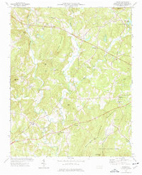
 1970 Randleman1973 Print · USGSRandolph County's industrial and rural landscape comes into focus in the early 1970s as the river-driven towns of Worthville and Central Falls thrive. Researchers can trace the legacy of local congregations at Old Union Ch and New Salem Ch or locate the site of the Drive-in Theater.2 unique versions available
 - 1970 Map of Asheboro, 1974 Print
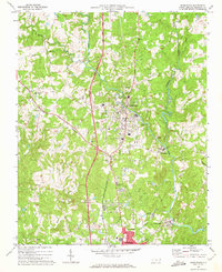
 1970 Asheboro1974 Print · USGSAsheboro and its surrounding Piedmont hills come into focus in the early seventies during a era of significant growth. Researchers can trace local landmarks like Hinshaw Airport, the Northwestern and Carolina rail line, and the emerging State Zoological Park.2 unique versions available
 - 1974 Map of Farmer, 1977 Print
 1974 Farmer1977 Print · USGSRandolph County in the mid-seventies reveals a landscape defined by the ancient peaks of the Uwharrie Mountains and traditional crossroads communities. Genealogists can trace family roots at Hoovers Grove Cem or locate old schoolhouses like Tabernacle Sch and rural settlements like Motleta.2 unique versions available
End of results
Showing maps 1-3 of 3
Top cities near Asheboro
- High Point historical maps
- Thomasville historical maps
- Archdale historical maps
- Trinity historical maps
- Pleasant Garden historical maps
- Randleman historical maps
See more
Top neighborhoods of Asheboro
- Cedar Creek historical maps
- Laurel Wood Hills historical maps
- North Asheboro historical maps
- Central Falls historical maps
- Redding Hills historical maps
- Wynn Gate historical maps
See more
Frequently asked questions
- What are the different types of historical maps available for Asheboro?
- What is the oldest map of Asheboro?
- Where can I purchase historical maps of Asheboro for my home or office?
- Where can I download high-res historical maps of Asheboro?
- Are there historical topographic maps available for Asheboro?
- Is there historical aerial imagery available for Asheboro?
- Where are historical maps of Asheboro sourced from?