1940s Maps of Illahee Hills, North Carolina
Explore 2 historic maps of Illahee Hills from the 1940s. These maps offer a rare glimpse into what life looked like during the 1940s — showing old roads, neighborhoods, homes, and landmarks that have changed or disappeared over time.
Whether you're researching your family's past, planning a metal detecting trip, or studying how Illahee Hills's landscape evolved across the 1940s, these high-resolution maps are a powerful tool for exploring the history of this region.
- Focus on a specific era: All maps on this page are from the 1940s, giving you a focused view of this time period.
- See what’s changed: Compare century-old streets, trails, and buildings to today's modern landscape using overlays and satellite layers.
- Research with precision: Use these maps for genealogy, historical research, land use analysis, or educational projects.
- View, download, or print: Maps are fully viewable online in high resolution, and can be downloaded or printed for your own records.
Start exploring Illahee Hills's history through authentic maps from the 1940s. This is your window into the past.
Illahee Hills, NC maps
(2)- 1945 Map of Rosman, 1957 Print
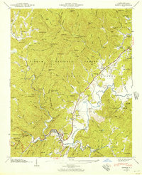 1945 Rosman1957 Print · USGSTransylvania County's river valleys and mountain gaps are captured here in the mid-1940s as the regional timber and rail economy thrived. Genealogists can locate family landmarks like Whitmire Cem, Zion Ch, and the State Prison Camp near Rosman.6 unique versions available
 - 1946 Map of Rosman, 1947 Print
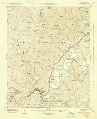 1946 Rosman1947 Print · USGSTransylvania County's mountain landscape comes to life in the mid-1940s as the railroad and river define the local economy. Researchers can locate family landmarks like the Whitmire Cem, rural pulpits such as Mt Moriah Ch, and the State Prison Camp near Rosman.
End of results
Showing maps 1-2 of 2
Top cities near Illahee Hills
- Asheville historical maps
- Fletcher historical maps
- Brevard historical maps
- Mills River historical maps
- Laurel Park historical maps
- Rosman historical maps
Frequently asked questions
- What are the different types of historical maps available for Illahee Hills?
- What is the oldest map of Illahee Hills?
- Where can I purchase historical maps of Illahee Hills for my home or office?
- Where can I download high-res historical maps of Illahee Hills?
- Are there historical topographic maps available for Illahee Hills?
- Is there historical aerial imagery available for Illahee Hills?
- Where are historical maps of Illahee Hills sourced from?