1970s Maps of Marshville, North Carolina
Explore 2 historic maps of Marshville from the 1970s. These maps offer a rare glimpse into what life looked like during the 1970s — showing old roads, neighborhoods, homes, and landmarks that have changed or disappeared over time.
Whether you're researching your family's past, planning a metal detecting trip, or studying how Marshville's landscape evolved across the 1970s, these high-resolution maps are a powerful tool for exploring the history of this region.
- Focus on a specific era: All maps on this page are from the 1970s, giving you a focused view of this time period.
- See what’s changed: Compare century-old streets, trails, and buildings to today's modern landscape using overlays and satellite layers.
- Research with precision: Use these maps for genealogy, historical research, land use analysis, or educational projects.
- View, download, or print: Maps are fully viewable online in high resolution, and can be downloaded or printed for your own records.
Start exploring Marshville's history through authentic maps from the 1970s. This is your window into the past.
Marshville, NC maps
(2)- 1970 Map of Marshville, 1973 Print
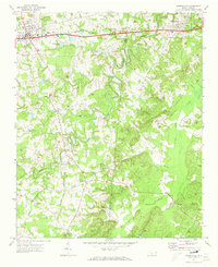 1970 Marshville1973 Print · USGSThe northern Piedmont at the start of the 1970s shows the transition from a rail-dependent economy to a highway-driven one. Genealogists can locate family landmarks such as Sturdivants Crossroads, Pine View Cem, and the rural Meltonville Ch.2 unique versions available
 - 1970 Map of Wingate, 1973 Print
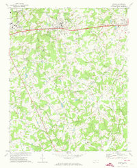 1970 Wingate1973 Print · USGSUnion County during the early 1970s shows the expansion of eastern MONROE and the growth of the Wingate College campus. Genealogists and local historians can trace family locations near Rock Rest, Allens Crossroads, or rural sites like Nicey Grove Ch.2 unique versions available
End of results
Showing maps 1-2 of 2
Top cities near Marshville
- Monroe historical maps
- Mint Hill historical maps
- Indian Trail historical maps
- Unionville historical maps
- Fairview historical maps
- Midland historical maps
See more
Frequently asked questions
- What are the different types of historical maps available for Marshville?
- What is the oldest map of Marshville?
- Where can I purchase historical maps of Marshville for my home or office?
- Where can I download high-res historical maps of Marshville?
- Are there historical topographic maps available for Marshville?
- Is there historical aerial imagery available for Marshville?
- Where are historical maps of Marshville sourced from?