
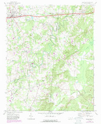
1970 Map of Marshville
USGS Topo · Published 1973About this map
Marshville and Peachland anchor the northern corridor of this region, connected by the Seaboard Coast Line railroad and a modern four-lane highway. The landscape south of these settlements is defined by a dense network of tributaries including Lanes Creek, Brown Creek, and Wide Mouth Branch, which cut through the terrain along the Union and Anson county line. This 1970s view reveals a rural infrastructure built around small communities and spiritual centers like Lanes Creek Ch, Mt Carmel Ch, and Bethel Ch.
Find a feature on this map
32 named features on this map. Tap any name to fly to it.
Don’t see what you’re looking for? This feature index may not catch every label — zoom into the map to look around manually.
Map Details
Editions of this 1970 Marshville Map
2 editions found
Other maps of this area

1941 · Spartanburg
USGS Topo · 1:250,000

1953 · Spartanburg
USGS Topo · 1:250,000

1953 · Charlotte
USGS Topo · 1:250,000

1954 · Charlotte
USGS Topo · 1:250,000

1960 · Charlotte
USGS Topo · 1:250,000

1960 · Spartanburg
USGS Topo · 1:250,000

1962 · Charlotte
USGS Topo · 1:250,000

1963 · Spartanburg
USGS Topo · 1:250,000

1964 · Spartanburg
USGS Topo · 1:250,000
1970 · Watson
USGS Topo · 1:24,000