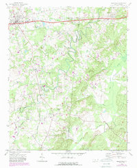
1970 Map of Marshville
USGS Topo · Published 1988About this map
Marshville and Peachland anchor the northern corridor of this landscape along the border of Union and Anson Counties. The terrain is defined by a dense network of waterways, with the meandering Lanes Creek carving a deep path south through the center of the sheet, joined by tributaries like Beaverdam Creek and Brown Creek. The mapping reveals a rural community structure organized around intersections and houses of worship, such as Lanes Creek Ch and Mt Carmel Ch.
Find a feature on this map
27 named features on this map. Tap any name to fly to it.
Don’t see what you’re looking for? This feature index may not catch every label — zoom into the map to look around manually.
Map Details
Editions of this 1970 Marshville Map
2 editions found

Other maps of this area

1941 · Spartanburg
USGS Topo · 1:250,000

1953 · Spartanburg
USGS Topo · 1:250,000

1953 · Charlotte
USGS Topo · 1:250,000

1954 · Charlotte
USGS Topo · 1:250,000

1960 · Charlotte
USGS Topo · 1:250,000

1960 · Spartanburg
USGS Topo · 1:250,000

1962 · Charlotte
USGS Topo · 1:250,000

1963 · Spartanburg
USGS Topo · 1:250,000

1964 · Spartanburg
USGS Topo · 1:250,000
1970 · Watson
USGS Topo · 1:24,000