1970s Maps of Monroe, North Carolina
Explore 5 historic maps of Monroe from the 1970s. These maps offer a rare glimpse into what life looked like during the 1970s — showing old roads, neighborhoods, homes, and landmarks that have changed or disappeared over time.
Whether you're researching your family's past, planning a metal detecting trip, or studying how Monroe's landscape evolved across the 1970s, these high-resolution maps are a powerful tool for exploring the history of this region.
- Focus on a specific era: All maps on this page are from the 1970s, giving you a focused view of this time period.
- See what’s changed: Compare century-old streets, trails, and buildings to today's modern landscape using overlays and satellite layers.
- Research with precision: Use these maps for genealogy, historical research, land use analysis, or educational projects.
- View, download, or print: Maps are fully viewable online in high resolution, and can be downloaded or printed for your own records.
Start exploring Monroe's history through authentic maps from the 1970s. This is your window into the past.
Monroe, NC maps
(5)- 1970 Map of Watson, 1973 Print
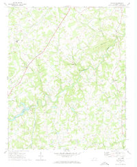 1970 Watson1973 Print · USGSUnion County, North Carolina, is depicted here in the early seventies as a landscape of small farming communities and winding creeks. Genealogists and local historians can trace family roots through numerous sites like Shiloh Ch, Fairfield, and the Williams Cem.2 unique versions available
 - 1970 Map of Wingate, 1973 Print
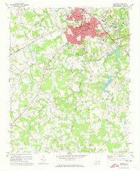
 1970 Wingate1973 Print · USGSUnion County during the early 1970s shows the expansion of eastern MONROE and the growth of the Wingate College campus. Genealogists and local historians can trace family locations near Rock Rest, Allens Crossroads, or rural sites like Nicey Grove Ch.2 unique versions available
 - 1971 Map of Bakers, 1973 Print
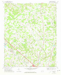 1971 Bakers1973 Print · USGSUnion County's rural crossroads and emerging suburbs are documented here in the early 1970s as the area around Monroe began to expand. Researchers can locate specific family landmarks including Union Grove Ch, the SEABOARD COAST LINE railway, and Bentons Crossroads.3 unique versions available
 - 1971 Map of Monroe, 1973 Print
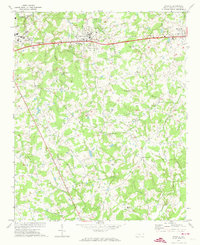
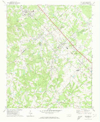
 1971 Monroe1973 Print · USGSMonroe was expanding as a regional hub in the early seventies, centered on a busy rail corridor and a network of rural crossroads. Local historians can trace family land near Roughedge, Alton, and several country churches like New Hope Church and Macedonia Church.2 unique versions available
 - 1971 Map of Matthews, 1973 Print
 1971 Matthews1973 Print · USGSSoutheast of Charlotte in the early 1970s, the rail-oriented communities of Union Co and Mecklenburg Co are caught in a moment of rapid suburban expansion. Local historians can trace old family church locations like Hudson Grove Ch and Maple Grove Ch alongside the busy Seaboard Coast Line.3 unique versions available
End of results
Showing maps 1-5 of 5
Top cities near Monroe
- Charlotte historical maps
- Matthews historical maps
- Mint Hill historical maps
- Indian Trail historical maps
- Waxhaw historical maps
- Weddington historical maps
See more
Top neighborhoods of Monroe
- Franklin Colony historical maps
- Lakeview Estates historical maps
- Northwood historical maps
- Park Place historical maps
- Rock Rest historical maps
- Roland Park historical maps
See more
Frequently asked questions
- What are the different types of historical maps available for Monroe?
- What is the oldest map of Monroe?
- Where can I purchase historical maps of Monroe for my home or office?
- Where can I download high-res historical maps of Monroe?
- Are there historical topographic maps available for Monroe?
- Is there historical aerial imagery available for Monroe?
- Where are historical maps of Monroe sourced from?