1960s Maps of Pickwick Village, Raleigh
Explore 2 historic maps of Pickwick Village from the 1960s. These maps offer a rare glimpse into what life looked like during the 1960s — showing old roads, neighborhoods, homes, and landmarks that have changed or disappeared over time.
Whether you're researching your family's past, planning a metal detecting trip, or studying how Pickwick Village's landscape evolved across the 1960s, these high-resolution maps are a powerful tool for exploring the history of this region.
- Focus on a specific era: All maps on this page are from the 1960s, giving you a focused view of this time period.
- See what’s changed: Compare century-old streets, trails, and buildings to today's modern landscape using overlays and satellite layers.
- Research with precision: Use these maps for genealogy, historical research, land use analysis, or educational projects.
- View, download, or print: Maps are fully viewable online in high resolution, and can be downloaded or printed for your own records.
Start exploring Pickwick Village's history through authentic maps from the 1960s. This is your window into the past.
Pickwick Village, Raleigh maps
(2)- 1967 Map of Bayleaf, 1972 Print
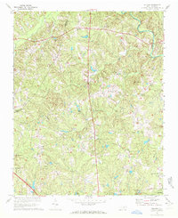 1967 Bayleaf1972 Print · USGSNorthern Wake County appears here in the late sixties, just before the rapid suburban growth of Raleigh began to transform these rural communities. Researchers can trace family sites near Wake-Minster, find the Soapstone Quarry, and locate old landmarks like Six Forks and Hickory Grove Ch.4 unique versions available
 - 1968 Map of Raleigh West, 1972 Print
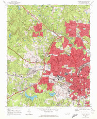 1968 Raleigh West1972 Print · USGSRaleigh in the late sixties reveals a city in rapid transition between its traditional downtown core and expanding suburban neighborhoods. Genealogists and historians can trace institutional landmarks like North Carolina State University alongside local settlements like Method and Asbury.6 unique versions available
End of results
Showing maps 1-2 of 2
Frequently asked questions
- What are the different types of historical maps available for Pickwick Village?
- What is the oldest map of Pickwick Village?
- Where can I purchase historical maps of Pickwick Village for my home or office?
- Where can I download high-res historical maps of Pickwick Village?
- Are there historical topographic maps available for Pickwick Village?
- Is there historical aerial imagery available for Pickwick Village?
- Where are historical maps of Pickwick Village sourced from?