1900s (20th Century) Maps of Enterprise, North Carolina
Explore 4 historic maps of Enterprise from the 1900s (20th Century). These maps offer a rare glimpse into what life looked like during the 1900s — showing old roads, neighborhoods, homes, and landmarks that have changed or disappeared over time.
Whether you're researching your family's past, planning a metal detecting trip, or studying how Enterprise's landscape evolved across the 1900s, these high-resolution maps are a powerful tool for exploring the history of this region.
- Focus on a specific era: All maps on this page are from the 1900s, giving you a focused view of this time period.
- See what’s changed: Compare century-old streets, trails, and buildings to today's modern landscape using overlays and satellite layers.
- Research with precision: Use these maps for genealogy, historical research, land use analysis, or educational projects.
- View, download, or print: Maps are fully viewable online in high resolution, and can be downloaded or printed for your own records.
Start exploring Enterprise's history through authentic maps from the 1900s. This is your window into the past.
Enterprise, NC maps
(4)- 1953 Map of Norfolk, 1954 Print
 1953 Norfolk1954 Print · USGSCoastal Virginia and northeastern North Carolina appear here during the post-war industrial boom, showing the critical rail-and-sea connections of Hampton Roads. Genealogists can trace family roots through rural landmarks like Gethsemane Ch, the Caledonia State Prison Farm, and the vast interior of the Dismal Swamp.4 unique versions available
 - 1973 Map of Littleton, 1977 Print
 1973 Littleton1977 Print · USGSThe border of Warren and Halifax Counties in the early 1970s is captured here as the Seaboard Coast Line passes through several rural communities. Researchers can trace the layout of Littleton, find Panacea Springs, and locate country churches like Ashley Grove Ch.
 - 1977 Map of Littleton, 1979 Print
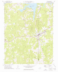
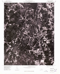 1977 Littleton1979 Print · USGSThe town of Littleton and the southern shores of Lake Gaston are captured in this late-seventies aerial survey of the North Carolina interior. Genealogists and historians can examine the precise layout of Littleton and nearby Vaughan or trace the timberlines near Enterprise.
 - 1985 Map of Roanoke Rapids
 1985 Roanoke Rapids1985 Print · USGSNorthern North Carolina's river-driven economy is on display here in the mid-1980s, from the hydro-power at Roanoke Rapids to the rural millponds. Genealogists can trace family lands near Wiccacanee Pond, Mush Island, or the remote Urahaw Swamp.2 unique versions available
End of results
Showing maps 1-4 of 4
Top cities near Enterprise
- Bracey historical maps
- Warrenton historical maps
- Gasburg historical maps
- Ebony historical maps
- Macon historical maps
Frequently asked questions
- What are the different types of historical maps available for Enterprise?
- What is the oldest map of Enterprise?
- Where can I purchase historical maps of Enterprise for my home or office?
- Where can I download high-res historical maps of Enterprise?
- Are there historical topographic maps available for Enterprise?
- Is there historical aerial imagery available for Enterprise?
- Where are historical maps of Enterprise sourced from?