1970s Maps of Warren Plains, North Carolina
Explore 2 historic maps of Warren Plains from the 1970s. These maps offer a rare glimpse into what life looked like during the 1970s — showing old roads, neighborhoods, homes, and landmarks that have changed or disappeared over time.
Whether you're researching your family's past, planning a metal detecting trip, or studying how Warren Plains's landscape evolved across the 1970s, these high-resolution maps are a powerful tool for exploring the history of this region.
- Focus on a specific era: All maps on this page are from the 1970s, giving you a focused view of this time period.
- See what’s changed: Compare century-old streets, trails, and buildings to today's modern landscape using overlays and satellite layers.
- Research with precision: Use these maps for genealogy, historical research, land use analysis, or educational projects.
- View, download, or print: Maps are fully viewable online in high resolution, and can be downloaded or printed for your own records.
Start exploring Warren Plains's history through authentic maps from the 1970s. This is your window into the past.
Warren Plains, NC maps
(2)- 1970 Map of Warrenton, 1973 Print
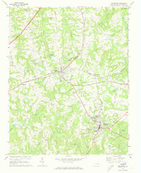 1970 Warrenton1973 Print · USGSWarren County at the start of the seventies centered on the rail junction at Norlina and the county seat of Warrenton. Genealogists can trace family names at Old Warrenton Cem or explore rural community life at Warren Plains and Snow Hill.
 - 1977 Map of Warrenton, 1979 Print
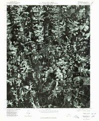 1977 Warrenton1979 Print · USGSWarren County in the late seventies is captured in this detailed aerial perspective of its primary settlements and rural corridors. Genealogists and local historians can trace the exact footprints of homes and businesses in Warrenton, Norlina, and Ridgeway.
End of results
Showing maps 1-2 of 2
Top cities near Warren Plains
- Henderson historical maps
- Bracey historical maps
- Norlina historical maps
- Warrenton historical maps
- Boydton historical maps
- Ebony historical maps
See more
Frequently asked questions
- What are the different types of historical maps available for Warren Plains?
- What is the oldest map of Warren Plains?
- Where can I purchase historical maps of Warren Plains for my home or office?
- Where can I download high-res historical maps of Warren Plains?
- Are there historical topographic maps available for Warren Plains?
- Is there historical aerial imagery available for Warren Plains?
- Where are historical maps of Warren Plains sourced from?